
Mapa topográfico Tiberias
Mapa interactivo
Haga clic en el mapa para ver la altitud.
Tiberias
Tiberias is located on the shore of the Sea of Galilee and the western slopes of the Jordan Rift Valley overlooking the lake, in the elevation range of −200 to 200 metres (−660–660 feet). Tiberias has a hot semi-arid climate (Köppen: BSh) that borders a hot-summer Mediterranean climate (Köppen: Csa), with an annual precipitation of 437.1 mm (17.21 in). Summers in Tiberias average a maximum temperature of 38 °C (100 °F) and a minimum temperature of 25 °C (77 °F) in July and August. The winters are mild, with temperatures ranging from 10 to 18 °C (50–64 °F). Extremes have ranged from 0 °C (32 °F) to 48 °C (118 °F).
Acerca de este mapa
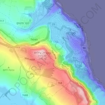
Nombre: Mapa topográfico Tiberias, altitud, relieve.
Lugar: Tiberias, Kinneret Subdistrict, North District, Israel (32.75402 35.49528 32.81215 35.56298)
Altitud media: -48 m
Altitud mínima: -218 m
Altitud máxima: 249 m
Otros mapas topográficos
Haga clic en un mapa para ver su topografía, su altitud y su relieve.
Golan Heights
Israel > North District > Golan Regional Council
The plateau that Israel controls is part of a larger area of volcanic basalt fields stretching north and east that were created in the series of volcanic eruptions that began recently in geological terms, almost 4 million years ago. The rock forming the mountainous area in the northern Golan Heights,…
Altitud media: 533 m
Matat
Israel > North District > Maale Yosef Regional Council
Mattat's name is equivalent in gematria to 840, its altitude in metres. The high location and mountainous region provides the town with a relatively temperate climate. Summer temperatures rarely break 30 °C and humidity is low, and summer nights are even chilly. The winters are cold and wet, with an average…
Altitud media: 755 m
Mount Meron
Israel > North District > Merom HaGalil Regional Council
Mount Meron (Hebrew: הַר מֵירוֹן, Har Meron; Arabic: جبل الجرمق, Jabal al-Jarmaq) is a mountain in the Upper Galilee region of Israel. It has special significance in Jewish religious tradition and parts of it have been declared a nature reserve. At 1,204 metres (3,950 ft) above sea level,…
Altitud media: 943 m
Avnay Eitan
Israel > North District > Golan Regional Council
Avnei Eitan (Hebrew: אַבְנֵי אֵיתָן) is an Israeli settlement organized as a moshav in the southern Golan Heights, located at an elevation of 385 meters (1,263 ft) above sea level. Located to the east of the Sea of Galilee, it falls under the municipal jurisdiction of Golan Regional Council. In…
Altitud media: 384 m
Meron
Israel > North District > Merom HaGalil Regional Council
Meron is noted for its mountainous terrain and valleys. Among the local attractions are the Meron Vineyards. Meron is conducive to growing grapes for wine as a result of its 600-meter altitude and chalky soil. The vineyard was first planted in 2000 and is part of the Galil Mountain Winery, headquartered in…
Altitud media: 735 m
Kiryat Shmona
Kiryat Shmona is located in the Finger of the Galilee next to Hula Valley, about 5 kilometres (3 miles) south and 2 km (1 mile) east of the Israel–Lebanon border. Its elevation is about 150 metres (492 feet) above sea level.
Altitud media: 227 m
Golan Heights
Israel > North District > Golan Regional Council
The Golan Heights is a basaltic plateau in southwestern Syria, extending about 44 miles (71 km) from north to south and about 27 miles (43 km) from east to west at its widest point, covering approximately 444 square miles (1,150 square km). The terrain is characterized by its hilly and elevated nature, with an…
Altitud media: 533 m
2236 Mt. Hermon
Israel > North District > Golan Regional Council
Mount Hermon (Arabic: جبل الشيخ / ALA-LC: Jabal al-Shaykh ('Mountain of the Sheikh', Levantine Arabic pronunciation: [ʒa.bal eʃ.ʃeːx]), Hebrew: הַר חֶרְמוֹן, Har Ḥermōn) is a mountain cluster constituting the southern end of the Anti-Lebanon mountain range. Its summit straddles the…
Altitud media: 2.016 m
Golan Heights
Israel > North District > Golan Regional Council
The plateau that Israel controls is part of a larger area of volcanic basalt fields stretching north and east that were created in the series of volcanic eruptions that began recently in geological terms, almost 4 million years ago. The rock forming the mountainous area in the northern Golan Heights,…
Altitud media: 533 m
Nazareth
As of the early 1990s, no city plans drafted by Nazareth Municipality have been approved by the government (both the British Mandate and later Israel) since 1942. This has left many people in Nazareth who vote in the city's municipal elections and receive services from its municipality effectively outside of…
Altitud media: 359 m
Tiberias
Tiberias is located on the shore of the Sea of Galilee and the western slopes of the Jordan Rift Valley overlooking the lake, in the elevation range of −200 to 200 metres (−660–660 feet). Tiberias has a climate that borders a Hot-summer Mediterranean climate (koppen Csa) and a Hot Semi-arid climate…
Altitud media: -2 m
Nazareth
Israel > North District > Nazareth
As of the early 1990s, no city plans drafted by Nazareth Municipality have been approved by the government (both the British Mandate and later Israel) since 1942. This has left many people in Nazareth who vote in the city's municipal elections and receive services from its municipality effectively outside of…
Altitud media: 151 m