
Mapa topográfico Maynard
Haga clic en el mapa para ver la altitud.
Maynard
According to the United States Census Bureau, the town has a total area of 5.4 square miles (13.9 km²), of which 5.2 square miles (13.6 km²) is land and 0.1 square miles (0.3 km²), or 2.42%, is water. Average elevation is roughly 200 feet (~61 m) above sea level; the highest point is Summer Hill, elevation 358 feet (109.1 m); the lowest is the Maynard/Acton border next to the Assabet River, at 145 feet (44.2 m).
Acerca de este mapa
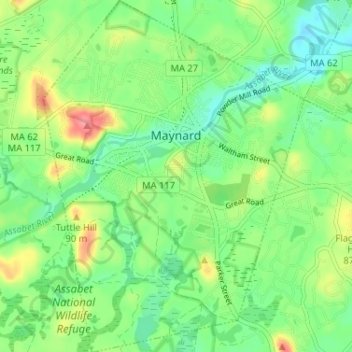
Nombre: Mapa topográfico Maynard, altitud, relieve.
Altitud media: 65 m
Altitud mínima: 38 m
Altitud máxima: 112 m
Otros mapas topográficos
Haga clic en un mapa para ver su topografía, su altitud y su relieve.
Medford Hillside
United States > Massachusetts > Middlesex County > Medford > West Medford
Altitud media: 13 m
Winchester Highlands
United States > Massachusetts > Middlesex County > Winchester
Altitud media: 35 m
Oak Hill
United States > Massachusetts > Middlesex County > Newton
This village is situated on a landform known since the mid-17th century as Oak Hill, and one of the seven principal elevations of Newton (the others being Nonantum Hill, Waban Hill, Chestnut Hill, Bald Pate Hill, Institution Hill, and Mount Ida).
Altitud media: 43 m
Hobbs Road
United States > Massachusetts > Middlesex County > Wayland > Cochituate
Altitud media: 66 m
Cambridge
United States > Massachusetts > Middlesex County > Cambridge
Cambridge obtains water from Hobbs Brook (in Lincoln and Waltham) and Stony Brook (Waltham and Weston), as well as an emergency connection to the Massachusetts Water Resources Authority. The city owns over 1,200 acres (486 ha) of land in other towns that includes these reservoirs and portions of their…
Altitud media: 31 m
Weston Station
United States > Massachusetts > Middlesex County > Weston > Weston Station
Altitud media: 55 m