
Haz una donación
Equípate para tu próxima aventura:
Como asociado de Amazon, este sitio gana comisiones por las compras que califican, sin ningún costo adicional para usted.
Mapa topográfico Grand Rapids
Haga clic en el mapa para ver la altitud.
Haz una donación
Equípate para tu próxima aventura:
Como asociado de Amazon, este sitio gana comisiones por las compras que califican, sin ningún costo adicional para usted.
Grand Rapids
Grand Rapids developed on the banks of the Grand River, where there was once a set of rapids, at an altitude of 610 feet (186 m) above sea level. Ships could navigate on the river up to this fall line, stopping because of the rapids. The river valley is flat and narrow, surrounded by steep hills and bluffs. The terrain becomes more rolling hills away from the river. The countryside surrounding the metropolitan area consists of mixed forest and farmland, with large areas of orchards to the northwest. It is approximately 25 mi (40 km) east of Lake Michigan. The state capital of Lansing lies about 60 mi (97 km) to the east-by-southeast, and Kalamazoo is about 50 mi (80 km) to the south.
Haz una donación
Equípate para tu próxima aventura:
Como asociado de Amazon, este sitio gana comisiones por las compras que califican, sin ningún costo adicional para usted.
Acerca de este mapa
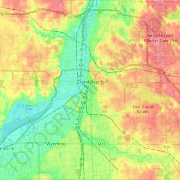
Nombre: Mapa topográfico Grand Rapids, altitud, relieve.
Lugar: Grand Rapids, Kent County, Michigan, United States (42.88365 -85.75187 43.02905 -85.56865)
Altitud media: 216 m
Altitud mínima: 178 m
Altitud máxima: 257 m
Haz una donación
Equípate para tu próxima aventura:
Como asociado de Amazon, este sitio gana comisiones por las compras que califican, sin ningún costo adicional para usted.
Otros mapas topográficos
Haga clic en un mapa para ver su topografía, su altitud y su relieve.
Haz una donación
Equípate para tu próxima aventura:
Como asociado de Amazon, este sitio gana comisiones por las compras que califican, sin ningún costo adicional para usted.
Haz una donación
Equípate para tu próxima aventura:
Como asociado de Amazon, este sitio gana comisiones por las compras que califican, sin ningún costo adicional para usted.
Haz una donación
Equípate para tu próxima aventura:
Como asociado de Amazon, este sitio gana comisiones por las compras que califican, sin ningún costo adicional para usted.