
Haz una donación
Equípate para tu próxima aventura:
Como asociado de Amazon, este sitio gana comisiones por las compras que califican, sin ningún costo adicional para usted.
Mapa topográfico Grattan
Haga clic en el mapa para ver la altitud.
Haz una donación
Equípate para tu próxima aventura:
Como asociado de Amazon, este sitio gana comisiones por las compras que califican, sin ningún costo adicional para usted.
Acerca de este mapa
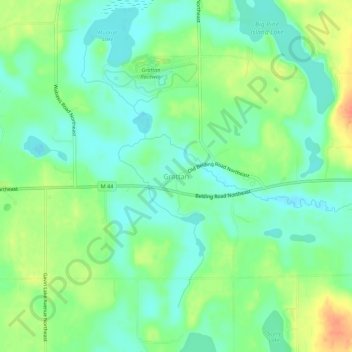
Nombre: Mapa topográfico Grattan, altitud, relieve.
Altitud media: 261 m
Altitud mínima: 244 m
Altitud máxima: 291 m
Haz una donación
Equípate para tu próxima aventura:
Como asociado de Amazon, este sitio gana comisiones por las compras que califican, sin ningún costo adicional para usted.
Otros mapas topográficos
Haga clic en un mapa para ver su topografía, su altitud y su relieve.
Grand Rapids
United States > Michigan > Kent County
Grand Rapids is situated in a region characterized by relatively flat terrain that gently undulates, influenced by the glacial activity that shaped much of the Midwest. The city itself sits at an elevation of approximately 640 feet (195 meters) above sea level, with the surrounding landscape showcasing low…
Altitud media: 216 m
Haz una donación
Equípate para tu próxima aventura:
Como asociado de Amazon, este sitio gana comisiones por las compras que califican, sin ningún costo adicional para usted.
Haz una donación
Equípate para tu próxima aventura:
Como asociado de Amazon, este sitio gana comisiones por las compras que califican, sin ningún costo adicional para usted.
Haz una donación
Equípate para tu próxima aventura:
Como asociado de Amazon, este sitio gana comisiones por las compras que califican, sin ningún costo adicional para usted.
Haz una donación
Equípate para tu próxima aventura:
Como asociado de Amazon, este sitio gana comisiones por las compras que califican, sin ningún costo adicional para usted.
Haz una donación
Equípate para tu próxima aventura:
Como asociado de Amazon, este sitio gana comisiones por las compras que califican, sin ningún costo adicional para usted.
Grand Rapids
United States > Michigan > Kent County
Grand Rapids developed on the banks of the Grand River, where there was once a set of rapids, at an altitude of 610 feet (186 m) above sea level. Ships could navigate on the river up to this fall line, stopping because of the rapids. The river valley is flat and narrow, surrounded by steep hills and bluffs.…
Altitud media: 216 m
Haz una donación
Equípate para tu próxima aventura:
Como asociado de Amazon, este sitio gana comisiones por las compras que califican, sin ningún costo adicional para usted.
Haz una donación
Equípate para tu próxima aventura:
Como asociado de Amazon, este sitio gana comisiones por las compras que califican, sin ningún costo adicional para usted.
Haz una donación
Equípate para tu próxima aventura:
Como asociado de Amazon, este sitio gana comisiones por las compras que califican, sin ningún costo adicional para usted.
Grand Rapids
United States > Michigan > Kent County
Grand Rapids developed on the banks of the Grand River, where there was once a set of rapids, at an altitude of 610 feet (186 m) above sea level. Ships could navigate on the river up to this fall line, stopping because of the rapids. The river valley is flat and narrow, surrounded by steep hills and bluffs.…
Altitud media: 216 m
Haz una donación
Equípate para tu próxima aventura:
Como asociado de Amazon, este sitio gana comisiones por las compras que califican, sin ningún costo adicional para usted.
Comstock Park
United States > Michigan > Kent County > Plainfield Charter Township
Altitud media: 206 m
Haz una donación
Equípate para tu próxima aventura:
Como asociado de Amazon, este sitio gana comisiones por las compras que califican, sin ningún costo adicional para usted.