Geolocalizar
👉 Easily get elevation data in JSON, GeoTIFF and KML formats using Elevation API
Gracias por apoyar a este sitio ❤️
Haz una donación

Equípate para tu próxima aventura:

Como asociado de Amazon, este sitio gana comisiones por las compras que califican, sin ningún costo adicional para usted.

Mapa topográfico New Chapel

Haga clic en el mapa para ver la altitud.

Acerca de este mapa

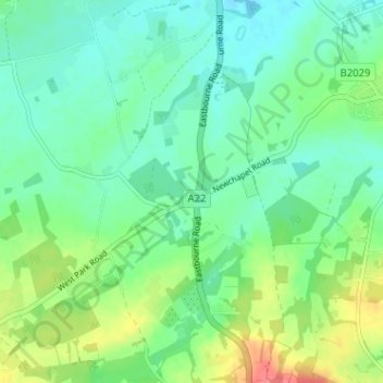
Nombre: Mapa topográfico New Chapel, altitud, relieve.

Lugar: New Chapel, Horne, Tandridge, Surrey, England, RH7 6NB, United Kingdom (51.14495 -0.07158 51.18495 -0.03158)

Altitud media: 64 m

Altitud mínima: 46 m

Altitud máxima: 105 m

Otros mapas topográficos

Haga clic en un mapa para ver su topografía, su altitud y su relieve.

Warlingham

United Kingdom > England > Surrey > Tandridge

Elevations vary from 110m AOD at Woldingham Road, at the southernmost point of the parish, with a gentle increase in height through the village along the main road heading to the southeast, to the highest elevation (199.6m) at Limpsfield Road.

Altitud media: 163 m

Tatsfield

United Kingdom > England > Surrey > Tandridge

Altitud media: 176 m

Oxted

United Kingdom > England > Surrey > Tandridge

Altitud media: 128 m

Chaldon

United Kingdom > England > Surrey > Tandridge

Altitud media: 181 m

Horne

United Kingdom > England > Surrey > Tandridge

Altitud media: 68 m

Burstow

United Kingdom > England > Surrey > Tandridge

Altitud media: 67 m

Crowhurst

United Kingdom > England > Surrey > Tandridge

Altitud media: 62 m

Woldingham

United Kingdom > England > Surrey > Tandridge

Altitud media: 183 m

Warlingham

United Kingdom > England > Surrey > Tandridge

Elevations vary from 110m AOD at Woldingham Road, at the southernmost point of the parish, with a gentle increase in height through the village along the main road heading to the southeast, to the highest elevation (199.6m) at Limpsfield Road.

Altitud media: 163 m

Equípate para tu próxima aventura:

🚲Bolsas de Sillín - Lleva tus herramientas y repuestos de forma compacta
Relojes Deportivos con GPS - Controla tu altitud, posición y ruta directamente en tu muñeca
Hamacas de Acampada - Ligereza máxima para dormir entre árboles
🏔️Equipamiento alta montaña - Material técnico para altitud
🥾Botas de Senderismo para Mujer - Comodidad y agarre diseñados para la anatomía del pie femenino

Como asociado de Amazon, este sitio gana comisiones por las compras que califican, sin ningún costo adicional para usted.