
Mapa topográfico Burstow
Haga clic en el mapa para ver la altitud.
Acerca de este mapa
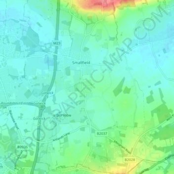
Nombre: Mapa topográfico Burstow, altitud, relieve.
Lugar: Burstow, Tandridge, Surrey, England, United Kingdom (51.13843 -0.14354 51.19157 -0.09372)
Altitud media: 67 m
Altitud mínima: 52 m
Altitud máxima: 121 m
Otros mapas topográficos
Haga clic en un mapa para ver su topografía, su altitud y su relieve.
Caterham
United Kingdom > England > Surrey > Tandridge
In 1840 Caterham contained a total of 477 residents (figures taken from that census, compiled in an 1848 topographical encyclopedia) and in 1848 468 acres (189 ha) of its 2,386 acres (966 ha) were common land. Similar to today, 175 acres (71 ha) mostly steeper acres were woodland.
Altitud media: 157 m
Botley Hill
United Kingdom > England > Surrey > Tandridge
Botley Hill is a Marilyn (a hill with topographic prominence of at least 150m), and the third highest point in the county (after the peaks of Leith Hill south of Dorking and Gibbet Hill in Hindhead, both on the Greensand Ridge).
Altitud media: 206 m
Caterham
United Kingdom > England > Surrey > Tandridge
In 1840 Caterham contained a total of 477 residents (figures taken from that census, compiled in an 1848 topographical encyclopedia) and in 1848 468 acres (189 ha) of its 2,386 acres (966 ha) were common land. Similar to today, 175 acres (71 ha) mostly steeper acres were woodland.
Altitud media: 157 m