
Mapa topográfico Horley
Mapa interactivo
Haga clic en el mapa para ver la altitud.
Acerca de este mapa
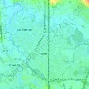
Nombre: Mapa topográfico Horley, altitud, relieve.
Lugar: Horley, Reigate and Banstead, Surrey, England, United Kingdom (51.15959 -0.19230 51.19230 -0.12775)
Altitud media: 58 m
Altitud mínima: 50 m
Altitud máxima: 92 m
Horley is at an altitude of around 54 metres above mean sea level.
Otros mapas topográficos
Haga clic en un mapa para ver su topografía, su altitud y su relieve.
Banstead
United Kingdom > England > Surrey > Reigate and Banstead
Banstead, Reigate and Banstead, Surrey, England, United Kingdom
Altitud media: 142 m
Merstham
United Kingdom > England > Surrey > Reigate and Banstead
Merstham, Reigate and Banstead, Surrey, England, RH1 3HT, United Kingdom
Altitud media: 119 m
Redhill
United Kingdom > England > Surrey > Reigate and Banstead
Redhill, Reigate and Banstead, Surrey, England, RH1 1RJ, United Kingdom
Altitud media: 107 m