
Mapa topográfico Banstead
Mapa interactivo
Haga clic en el mapa para ver la altitud.
Acerca de este mapa
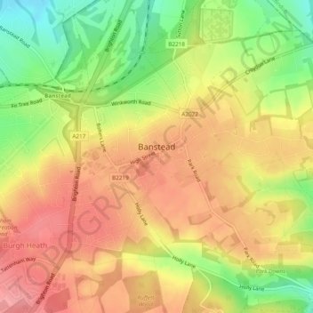
Nombre: Mapa topográfico Banstead, altitud, relieve.
Altitud media: 142 m
Altitud mínima: 88 m
Altitud máxima: 180 m
Otros mapas topográficos
Haga clic en un mapa para ver su topografía, su altitud y su relieve.
Merstham
United Kingdom > England > Surrey > Reigate and Banstead
Merstham, Reigate and Banstead, Surrey, England, RH1 3HT, United Kingdom
Altitud media: 119 m
Redhill
United Kingdom > England > Surrey > Reigate and Banstead
Redhill, Reigate and Banstead, Surrey, England, RH1 1RJ, United Kingdom
Altitud media: 107 m
Horley
United Kingdom > England > Surrey > Reigate and Banstead
Horley, Reigate and Banstead, Surrey, England, United Kingdom
Altitud media: 58 m