Geolocalizar

Mapa topográfico Brockham

Haga clic en el mapa para ver la altitud.

Acerca de este mapa

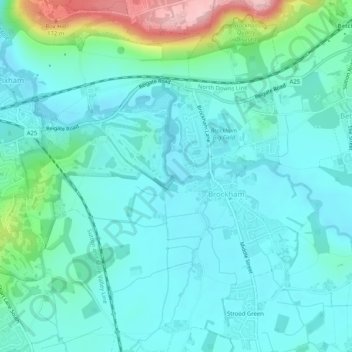
Nombre: Mapa topográfico Brockham, altitud, relieve.

Lugar: Brockham, Mole Valley, Surrey, England, United Kingdom (51.21744 -0.32177 51.24961 -0.27309)

Altitud media: 73 m

Altitud mínima: 38 m

Altitud máxima: 219 m

👉 Easily get elevation data in JSON, GeoTIFF and KML formats using Elevation API
Gracias por apoyar a este sitio ❤️
Haz una donación

Equípate para tu próxima aventura:

Como asociado de Amazon, este sitio gana comisiones por las compras que califican, sin ningún costo adicional para usted.

Otros mapas topográficos

Haga clic en un mapa para ver su topografía, su altitud y su relieve.

Box Hill

United Kingdom > England > Surrey > Mole Valley > Pixham

The 15.8 km (9.8 mi) Box Hill Olympic circuit is generally cycled in an anticlockwise direction and begins to the south of the village of Mickleham with an ascent of the hill via the Zig Zag Road. From the National Trust Visitor Centre, the route turns eastwards, running along the escarpment and through the…

Altitud media: 105 m

Dorking

United Kingdom > England > Surrey > Mole Valley

Altitud media: 107 m

Ashtead

United Kingdom > England > Surrey > Mole Valley

Altitud media: 75 m

Broadmoor

United Kingdom > England > Surrey > Mole Valley

Altitud media: 175 m

Westhumble

United Kingdom > England > Surrey > Mole Valley

Altitud media: 97 m

Vale Farm

United Kingdom > England > Surrey > Mole Valley

Altitud media: 136 m

Hookwood

United Kingdom > England > Surrey > Mole Valley

Altitud media: 60 m

Leith Hill

United Kingdom > England > Surrey > Mole Valley

Altitud media: 196 m

Westcott

United Kingdom > England > Surrey > Mole Valley

Altitud media: 116 m

Beare Green

United Kingdom > England > Surrey > Mole Valley

Altitud media: 107 m

Box Hill

United Kingdom > England > Surrey > Mole Valley > Pixham

The 15.8 km (9.8 mi) Box Hill Olympic circuit is generally cycled in an anticlockwise direction and begins to the south of the village of Mickleham with an ascent of the hill via the Zig Zag Road. From the National Trust Visitor Centre, the route turns eastwards, running along the escarpment and through the…

Altitud media: 105 m

Capel

United Kingdom > England > Surrey > Mole Valley

Altitud media: 91 m

Lodge Hill

United Kingdom > England > Surrey > Mole Valley

Altitud media: 110 m

Gracias por apoyar a este sitio ❤️
Haz una donación

Equípate para tu próxima aventura:

Como asociado de Amazon, este sitio gana comisiones por las compras que califican, sin ningún costo adicional para usted.

Dorking

United Kingdom > England > Surrey > Mole Valley

Altitud media: 107 m

Dorking

United Kingdom > England > Surrey > Mole Valley

Altitud media: 107 m

Ashtead

United Kingdom > England > Surrey > Mole Valley

Altitud media: 75 m

Dorking

United Kingdom > England > Surrey > Mole Valley

Altitud media: 107 m

Equípate para tu próxima aventura:

👟Zapatillas de Trail Running Mujer - Equilibrio perfecto entre ligereza y protección en montaña
🩲Ropa Interior Técnica - Evita rozaduras y evacua el sudor
📏Altímetros barométricos - Control de altitud para montaña y trekking
📻Radios de Emergencia - Información meteorológica sin necesidad de pilas
🧴Impermeabilizante para Botas - Spray protector para mantener tus pies secos en cualquier mapa

Como asociado de Amazon, este sitio gana comisiones por las compras que califican, sin ningún costo adicional para usted.