Geolocalizar

Mapa topográfico Dorking

Haga clic en el mapa para ver la altitud.

Acerca de este mapa

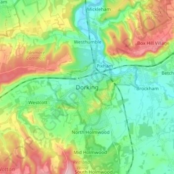
Nombre: Mapa topográfico Dorking, altitud, relieve.

Lugar: Dorking, Mole Valley, Surrey, England, RH4 1AQ, United Kingdom (51.19252 -0.37067 51.27252 -0.29067)

Altitud media: 107 m

Altitud mínima: 36 m

Altitud máxima: 247 m

Otros mapas topográficos

Haga clic en un mapa para ver su topografía, su altitud y su relieve.

Dorking

United Kingdom > England > Surrey > Mole Valley

Altitud media: 80 m

Capel

United Kingdom > England > Surrey > Mole Valley > Capel

Altitud media: 102 m

Ockley

United Kingdom > England > Surrey > Mole Valley > Ockley

Altitud media: 90 m

Leigh

United Kingdom > England > Surrey > Mole Valley > Leigh

Altitud media: 63 m

Wotton

United Kingdom > England > Surrey > Mole Valley

Altitud media: 135 m

Betchworth

United Kingdom > England > Surrey > Mole Valley

Altitud media: 81 m

Newdigate

United Kingdom > England > Surrey > Mole Valley

Altitud media: 86 m

Headley

United Kingdom > England > Surrey > Mole Valley > Headley

Altitud media: 146 m

Brockham

United Kingdom > England > Surrey > Mole Valley

Altitud media: 73 m

Dorking

United Kingdom > England > Surrey > Mole Valley

Altitud media: 80 m

Equípate para tu próxima aventura:

🧱Fundas impermeables móvil - Protección del smartphone
🪢Cuerda paracord - Cuerda resistente multiusos
🛌Almohadas Hinchables - Confort extra en tus noches de acampada
🧢Sombreros de montaña - Protección solar extendida
🧴Cremas Anti-rozaduras - Protección para pies y muslos en rutas largas

Como asociado de Amazon, este sitio gana comisiones por las compras que califican, sin ningún costo adicional para usted.