
Mapa topográfico Camiguin
Haga clic en el mapa para ver la altitud.
Camiguin
Camiguin Island is a pearl-shaped island with an area of approximately 238 km2 (92 sq mi). The island measures about 23 kilometres (14 mi) at its longest and 14.5 kilometres (9.0 mi) at its widest breadth. The island is mountainous with the highest elevation reaching over 5,000 ft (1,500 m). It is encircled by a national road with a length of about 64 kilometres (40 mi). As of the August 1, 2007, census, the province has a fifth-class income classification with a population of 81,293.
Acerca de este mapa
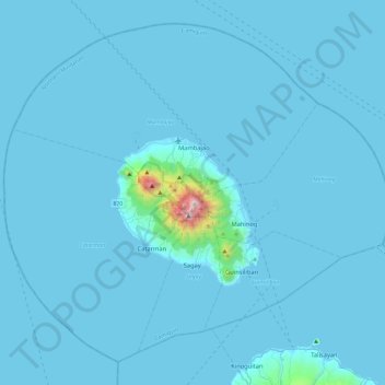
Nombre: Mapa topográfico Camiguin, altitud, relieve.
Lugar: Camiguin, Northern Mindanao, Philippines (8.98883 124.49669 9.39311 124.96259)
Altitud media: 35 m
Altitud mínima: -1 m
Altitud máxima: 1.601 m
Otros mapas topográficos
Haga clic en un mapa para ver su topografía, su altitud y su relieve.
Baguio
In 1903, Filipinos, Japanese and Chinese workers were hired to build Kennon Road, the first road directly connecting Baguio with the lowlands of La Union and Pangasinan. Before this, the only road to Benguet was Naguilian Road, and it was largely a horse trail at higher elevations. Camp John Hay was…
Altitud media: 881 m
Quezon City
Founded as a pueblo by Saint Pedro Bautista in 1590, San Francisco del Monte may be considered Quezon City's oldest district. The original land area of the old town of San Francisco del Monte was approximately2.5 square kilometres (1.0 sq mi) and covered parts of what is currently known as Project 7 and 8 and…
Altitud media: 57 m
Tagaytay
The southern and eastern portions of Tagaytay are covered by hills and mountains which is generally forests, pine trees and open grasslands. The city lies along Tagaytay Ridge, a ridge stretching about 32 kilometres (20 mi) from Mount Batulao in the west to Mount Sungay in the east with elevations averaging…
Altitud media: 229 m
Dumaguete
Philippines > Negros Oriental > Dumaguete
As a coastal city, it is bounded on the east by the Bohol Sea and the Tañon Strait, serving as a natural border of southeastern Negros Island Region to the neighboring Central Visayas. The city's topography is generally flat from two to six kilometers from the shoreline. It slopes gently upwards to the…
Altitud media: 167 m
Valenzuela
The highest elevation point is 38 meters (125 ft) above sea level. Having a surface gradient of 0.55% and a gentle slope, hilly landscape is located in the industrial section of the city in Canumay. The average elevation point is 2 meters (6.6 ft) above sea level.
Altitud media: 24 m
Mount Guiwan
Mount Guiwan is a mountain in the Sierra Madre range in Alfonso Castañeda, Nueva Vizcaya, Philippines. It is probably the highest peak of Sierra Madre mountain range with a height of at least 1,915 metres (6,283 ft) above sea level according to NAMRIA topographic map and perhaps as high as 1,950 metres (6,400…
Altitud media: 1.462 m
Indang
Philippines > Cavite > Indang
The topography of Indang is characterised by gently sloping or rolling terrain. Almost 40.36% of its total land area is within the slope grade of 3-8%, while 2,135 hectares is within the slope range of 8-15% which is characterised by undulating or sloping terrain.
Altitud media: 298 m