
Mapa topográfico Camarines Sur
Haga clic en el mapa para ver la altitud.
Acerca de este mapa
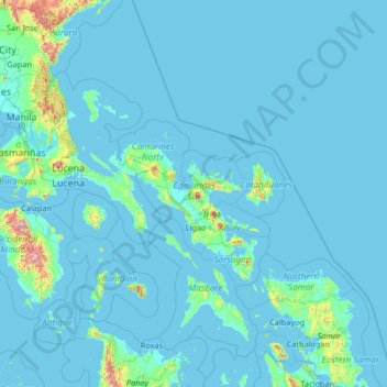
Nombre: Mapa topográfico Camarines Sur, altitud, relieve.
Lugar: Camarines Sur, Bicol Region, Philippines (11.06618 120.72652 16.26618 125.92652)
Altitud media: 56 m
Altitud mínima: -2 m
Altitud máxima: 2.388 m
Otros mapas topográficos
Haga clic en un mapa para ver su topografía, su altitud y su relieve.
Metro Manila
The Coastal Margin or Lowland is a flat and low plain that faces Manila Bay. Located here is Manila, Navotas, parts of Malabon, and the western part and reclaimed areas of Pasay and Parañaque, where the ground elevation ranges from zero meters on Manila Bay to five meters at the west side of the cities of…
Altitud media: 43 m
Laguna
Laguna is home to 24 mountains, most of which are inactive volcanoes. The highest peak in Laguna is Mt. Banahaw, with an elevation of 2,170 m (7,120 ft). Banahaw, unlike most other volcanoes in Laguna, is an active complex stratovolcano, which last erupted in 1843. Banahaw is located in the boundary of Laguna…
Altitud media: 183 m
Bukidnon
Situated within Bukidnon is Mount Dulang-dulang, the 2nd highest mountain in the country, with an elevation of 2,938 metres (9,639 ft) located in the Kitanglad Mountain Range. Mount Kitanglad (2,899 m), Mount Kalatungan (2,860 m), Mount Maagnaw (2,742 m), Mount Lumuluyaw (2,612 m), and Mount Tuminungan (2,400…
Altitud media: 686 m
Batangas
Batangas is a combination of plains and mountains, including one of the world's smallest volcanoes, Mt. Taal, with an elevation of 600 metres (2,000 ft), located in the middle of the Taal Lake. Other important peaks are Mount Macolod with an elevation of 830 metres (2,720 ft), Mt. Banoy with 960 metres (3,150…
Altitud media: 126 m
Bataan
Bataan is divided by two mountain groups of volcanic origins. The northern side is composed of the Mount Natib (elevation 1,253 metres (4,111 ft)), Mount Sta. Rosa and Mount Silangan. The southern group is composed of Mount Mariveles, Mount Samat, and Mount Cuyapo. A narrow pass separates these two mountain…
Altitud media: 70 m
Palawan
Palawan's almost 2,000 kilometers (1,200 mi) of irregular coastline is lined with rocky coves and sugar-white sandy beaches. It also harbors a vast stretch of virgin forests that carpet its chain of mountain ranges. The mountain heights average 1,100 meters (3,500 ft) in altitude, with the highest peak rising…
Altitud media: 44 m
Cagayan de Oro
Cagayan de Oro, located along the north-central coast of Mindanao, Philippines, encompasses a diverse topography that significantly influences its terrain. The city spans approximately 488.86 square kilometers (188.75 square miles), featuring a 25-kilometer (16 miles) coastline along Macajalar Bay. The…
Altitud media: 224 m
Mindanao
In the eastern portion of the island, from Bilas Point in Surigao del Norte to Cape San Agustin in Davao Oriental, is a range of complex mountains, called the Eastern Pacific Cordillera, known in their northern portion as the Diwata Mountains. This range is low and rolling in its central portion. A proposed…
Altitud media: 149 m
Muntinlupa
There are three plausible origins of the name of the city: First, is its association with the thin topsoil in the area; second, residents, purportedly replying to a question by Spaniards in the 16th century what the name of their place was, said “Monte sa Lupa”—apparently mistaking the question for what…
Altitud media: 21 m
Quezon City
In order to make Quezon's dream a reality and to mobilize funds for the land purchase, the People's Homesite Corporation (PHC) was created on October 14, 1938, as a subsidiary of NDC, with an initial capital of ₱2 million. Roces was the chairman of the Board of PHC, and they immediately acquired the vast…
Altitud media: 39 m
Antipolo
Its higher elevation than that of Metro Manila affords it a scenic view of the metropolitan area, especially at night. Its locally grown mangoes and cashews are popular among tourists, as well as suman – a local delicacy made out of glutinous rice. The Hinulugang Taktak National Park, which was once a…
Altitud media: 157 m
Aurora
The province covers a portion of the Sierra Madre mountain range. As such, the elevation is generally steep to very steep and only about 14% of the province's total area is flat.
Altitud media: 255 m
Cavite
Another theory proposes that the name is a Hispanicized form of kabit, Tagalog for "joined", "connected", or "attached", referring to the peninsula's topographical relation to the mainland. Edmund Roberts, in his 1821 memoir, stated that the "natives" called it Caveit due to the "crooked point of land…
Altitud media: 88 m
Carigara
The climatic and topographical characteristics of Carigara's expansive terrain, encompassing wide rice fields and hilly landscapes, create an optimal environment for cultivating fruit-bearing trees, vegetables, and a variety of crops. Noteworthy fruit-bearing trees suitable for cultivation include bananas,…
Altitud media: 134 m
Metro Manila
The Coastal Margin or Lowland is a flat and low plain that faces Manila Bay. Located here is Manila, Navotas, parts of Malabon, and the western part and reclaimed areas of Pasay and Parañaque, where the ground elevation ranges from zero meters on Manila Bay to five meters at the west side of the cities of…
Altitud media: 43 m
Laguna de Bay
Laguna de Bay (Spanish for "Lagoon/Lake of Bay"; Tagalog: Lawa ng Bay, [baɪ]), also known as Laguna Lake, is the largest lake in the Philippines. It is located southeast of Metro Manila, between the provinces of Laguna to the south and Rizal to the north. A freshwater lake, it has a surface area of 911–949…
Altitud media: 62 m
Isabela
The province is divided into three physiographic areas. The eastern area, straddled by the Sierra Madre mountain range, is rugged and thickly forested. A substantial portion is uncharted. These unexplored hinterlands are home to a rich variety of flora and fauna, and some are under government reservations. It…
Altitud media: 227 m
Negros Oriental
The province's topography is characterized by low, grooved mountain ranges of which some lie close to the shoreline. At the southern end of the province is Mount Talinis, also known as Cuernos de Negros ("Horns of Negros"), which is a dormant complex volcano which rises to a height of 2,000 metres (6,600 ft).…
Altitud media: 116 m
Mindoro
Philippines > Occidental Mindoro
Mindoro is the seventh largest and eighth-most populous island in the Philippines. With a total land area of 10,571 km2 ( 4,082 sq.mi ) and has a population of 1,408,454 as of 2020 census. It is located off the southwestern coast of Luzon and northeast of Palawan. Mindoro is divided into two provinces:…
Altitud media: 173 m
Basilan
Basilan National Park is at the eastern portion of the remaining public forest between the city of Isabela and the municipalities of Lamitan, Tipo-Tipo and Sumisip. The park has an elevation of 971 metres (3,186 ft) above sea level, and the tallest peak, Puno Mahaji or Basilan Peak, dominates the park's…
Altitud media: 32 m
Balut Island
Philippines > Davao Occidental > Sarangani
Balut Island, the westernmost of the Sarangani Islands, is the larger, higher, and better cultivated than Sarangani Island. In the center of the island is Balut Volcano, which is fumarolic on occasion. Balut Island rises to about 1,800 metres (5,900 ft) from the seabed with the highest elevation at 862 metres…
Altitud media: 87 m
Iloilo
The province is divided into two distinct geographic regions; the highlands of the Central Panay Mountain Range on the western border and the lowland plains which account for a larger portion of the province. Small islands east of its northernmost tip also dot the Visayan Sea - of these, Pan de Azucar and…
Altitud media: 129 m
Zamboanga City
The overall topography of the city could be described as rolling to very steep. There are some flat lands, mostly narrow strips along the east coast. The urban center is mostly flat with a gentle slope to the interior, ranging from 0% to 3%. A portion, about 38,000 hectares, has slopes ranging from 18% to 30%.…
Altitud media: 78 m
Angeles
Sapangbato is the largest barangay in Angeles in terms of territory, with a total land area of 104,694 sq. meters and a population of 11,262. Located northwest of Angeles near Clark Freeport Zone, it is identified as the barangay in Angeles with the highest elevation of 750 feet above sea level. It is home to…
Altitud media: 98 m
Marikina River
The river's depth ranges from 3 to 21 metres (9.8 to 68.9 ft) and spans from 70 to 120 metres (230 to 390 ft). It has a total area of nearly 75.2 hectares (0.752 km2) and is 27 kilometres (17 mi) long. The riverbank has an elevation of 8 meters above sea level at the boundary of San Mateo and Marikina. This…
Altitud media: 66 m
Negros Occidental
Negros Occidental has a tropical climate due to the fact that it is situated close to the equator, being located at least nine degrees north of it. The northern section of the province has a tropical rainforest (Köppen: Af) climate, whereas the southern portion has a tropical monsoon (Köppen: Am) climate.…
Altitud media: 126 m
Sibuyan Island
Sibuyan is a crescent-shaped island, the second largest in an archipelago comprising Romblon Province, Philippines. Located in the namesake Sibuyan Sea, it has an area of 445 square kilometres (172 sq mi) and has a total population of 62,815, as of the 2020 census. The island has two prominent peaks, the…
Altitud media: 182 m
Dinagat Islands
Dinagat Islands is a young island-province at the northern tip of Mindanao. Many describe Dinagat Islands as a hidden gem of the Caraga Region XIII. The Islands are enriched with great bio-diversity, abundant natural wonders and rich resources. Dinagat Islands has a multitude of fascinating white sandy beaches…
Altitud media: 24 m
San Jose del Monte
The elevation of the city ranges from approximately 40 to 900 meters (130 to 2,950 ft) above sea level; the relief transitions from warm lowland to cool upland as one goes eastward. This is because the city is part of the Sierra Madre mountain range. Plains and river valley flats characterize the western and…
Altitud media: 73 m
Tabaco
The City of Tabaco is located on the eastern coast of Albay province with an area of 117.14 km2 (45.23 sq mi). The terrain in the poblacion or town center of Tabaco is generally flat with the highest elevation at around 5 m (16 ft). The northwestern portion reaches 400 m (1,300 ft) above sea level. The city's…
Altitud media: 164 m
Dumaguete
As a coastal city, it is bounded on the east by the Bohol Sea and the Tañon Strait, serving as a natural border of southeastern Negros Island Region to the neighboring Central Visayas. The city's topography is generally flat from two to six kilometers from the shoreline. It slopes gently upwards to the…
Altitud media: 56 m
Isabela
The elevation of Isabela to 4th-class city status gave the local government a much-needed boost, efficiently delivered under the Biel administration, revitalized Isabela City, making it an engine of growth for Basilan province even as the hinterlands was wracked by incessant firefights and gun-battles between…
Altitud media: 93 m
Manito
Manito is located on the south-eastern tip of Albay, adjoining the south-eastern limit of Legazpi City. The west and NW coast of Manito lies along Poliqui Bay opposite the city of Legazpi. To the north and north-east coast of the municipality lies Albay Gulf. To the east and south of Manito is the province of…
Altitud media: 121 m
Baguio
In 1903, Filipinos, Japanese and Chinese workers were hired to build Kennon Road, the first road directly connecting Baguio with the lowlands of La Union and Pangasinan. Before this, the only road to Benguet was Naguilian Road, and it was largely a horse trail at higher elevations. Camp John Hay was…
Altitud media: 1.371 m
Cotabato City
The city is situated in the lowest portion of Maguindanao province. The City of Cotabato with its 37 barangays spans an area with marked landscapes of flat, level to nearly level, very gently sloping to gently undulations to moderately sloping or rolling. It is basically a delta formed by two big rivers, the…
Altitud media: 66 m
Siniloan
Buruwisan falls is located in Siniloan Laguna which is around eighty kilometers east of Manila. To get there we had to cross the long winding roads of Teresa and Bugarin to Mabitac. By public transport Take UV express vans bound to Tanay market in Starmall-Shaw terminal (P70). Then in Tanay market, ride a…
Altitud media: 120 m
Indang
The topography of Indang is characterised by gently sloping or rolling terrain. Almost 40.36% of its total land area is within the slope grade of 3-8%, while 2,135 hectares is within the slope range of 8-15% which is characterised by undulating or sloping terrain.
Altitud media: 328 m