
Mapa topográfico Grahamsville
Mapa interactivo
Haga clic en el mapa para ver la altitud.
Acerca de este mapa
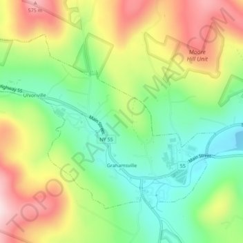
Nombre: Mapa topográfico Grahamsville, altitud, relieve.
Altitud media: 397 m
Altitud mínima: 249 m
Altitud máxima: 596 m
Grahamsville is located at latitude 41.848 and longitude -74.548. The elevation is 968 feet. Grahamsville is in the Eastern Time Zone.
Otros mapas topográficos
Haga clic en un mapa para ver su topografía, su altitud y su relieve.
Claryville
United States > New York > Sullivan County > Town of Neversink
Claryville, Town of Neversink, Sullivan County, New York, 12725, United States
Altitud media: 628 m
Unionville
United States > New York > Sullivan County > Town of Neversink
Unionville, Grahamsville, Town of Neversink, Sullivan County, New York, 12740, United States
Altitud media: 450 m
Willowemoc
United States > New York > Sullivan County > Town of Neversink
Willowemoc, Town of Neversink, Sullivan County, New York, United States
Altitud media: 630 m