Geolocalizar

Mapa topográfico Calbourne

Haga clic en el mapa para ver la altitud.

Acerca de este mapa

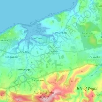
Nombre: Mapa topográfico Calbourne, altitud, relieve.

Lugar: Calbourne, Isle of Wight, England, United Kingdom (50.65901 -1.44520 50.74697 -1.33172)

Altitud media: 45 m

Altitud mínima: -2 m

Altitud máxima: 212 m

Otros mapas topográficos

Haga clic en un mapa para ver su topografía, su altitud y su relieve.

Niton

United Kingdom > England > Isle of Wight

Altitud media: 79 m

Arreton

United Kingdom > England > Isle of Wight

Altitud media: 50 m

Roud

United Kingdom > England > Isle of Wight > Godshill

Altitud media: 75 m

Cranmore

United Kingdom > England > Isle of Wight

Altitud media: 12 m

Winford

United Kingdom > England > Isle of Wight

Altitud media: 30 m

Newport

United Kingdom > England > Isle of Wight

Altitud media: 45 m

Gurnard

United Kingdom > England > Isle of Wight

Altitud media: 18 m

Binstead

United Kingdom > England > Isle of Wight > Ryde

Altitud media: 23 m

Bierley

United Kingdom > England > Isle of Wight > Whitwell

Altitud media: 105 m

Newport

United Kingdom > England > Isle of Wight

Altitud media: 45 m

Newport

United Kingdom > England > Isle of Wight

Altitud media: 45 m

Newport

United Kingdom > England > Isle of Wight

Altitud media: 45 m

Equípate para tu próxima aventura:

🛰️Localizadores GPS de emergencia - Seguridad en zonas aisladas
💦Filtros de Agua Portátiles - Bebe directamente de arroyos con total seguridad
🧱Fundas impermeables móvil - Protección del smartphone
🛏️Sacos de dormir - Sacos térmicos para montaña
Relojes Deportivos con GPS - Controla tu altitud, posición y ruta directamente en tu muñeca

Como asociado de Amazon, este sitio gana comisiones por las compras que califican, sin ningún costo adicional para usted.