Geolocalizar
👉 Easily get elevation data in JSON, GeoTIFF and KML formats using Elevation API
Gracias por apoyar a este sitio ❤️
Haz una donación

Equípate para tu próxima aventura:

Como asociado de Amazon, este sitio gana comisiones por las compras que califican, sin ningún costo adicional para usted.

Mapa topográfico Newport

Haga clic en el mapa para ver la altitud.

👉 Easily get elevation data in JSON, GeoTIFF and KML formats using Elevation API
Gracias por apoyar a este sitio ❤️
Haz una donación

Acerca de este mapa

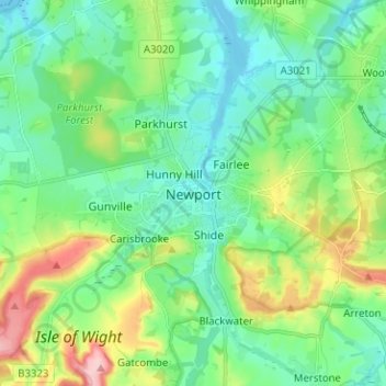
Nombre: Mapa topográfico Newport, altitud, relieve.

Lugar: Newport, Isle of Wight, England, PO30 5HD, United Kingdom (50.66037 -1.33520 50.74037 -1.25520)

Altitud media: 45 m

Altitud mínima: -3 m

Altitud máxima: 165 m

Otros mapas topográficos

Haga clic en un mapa para ver su topografía, su altitud y su relieve.

Ryde

United Kingdom > England > Isle of Wight

Altitud media: 21 m

Ventnor

United Kingdom > England > Isle of Wight

Ventnor's landmarks arise from its natural environment, its Victorian heritage, and its tourist appeal past and present. Although modest in altitude at 241 metres (791 ft), the chalk St Boniface Down is 1⁄2 mile (0.80 km) north of the town. The downs have a thick layer of acid flint gravels, with dry…

Altitud media: 58 m

Bembridge

United Kingdom > England > Isle of Wight

Close to the lifeboat station lies a coastguard lookout. Positioned at a high elevation, this offers views of the Solent meeting the English Channel to the east of the Isle of Wight. From this vantage point one is able to view a variety of watercraft year round, although there is more marine traffic in the…

Altitud media: 9 m

Shorwell

United Kingdom > England > Isle of Wight

Altitud media: 66 m

Shanklin

United Kingdom > England > Isle of Wight

Altitud media: 52 m

Chale

United Kingdom > England > Isle of Wight

Altitud media: 61 m

Arreton

United Kingdom > England > Isle of Wight

Altitud media: 46 m

Lake

United Kingdom > England > Isle of Wight

Lake is a seaside village situated above the cliffs on Sandown bay, it stands at an elevation of 63 feet (19 m) above sea-level. Lake's beach or 'Welcome Beach' has golden sands and reached by a steep path down the sandstone cliffs to the Revetment. It has two cafes (Hinks and Strollers), beach huts, a Sea…

Altitud media: 13 m

Sandown

United Kingdom > England > Isle of Wight

Altitud media: 18 m

Brading

United Kingdom > England > Isle of Wight

Altitud media: 29 m

Godshill

United Kingdom > England > Isle of Wight

Altitud media: 72 m

Cowes

United Kingdom > England > Isle of Wight

Altitud media: 25 m

Wroxall

United Kingdom > England > Isle of Wight

Altitud media: 128 m

Totland

United Kingdom > England > Isle of Wight

Altitud media: 21 m

Ryde

United Kingdom > England > Isle of Wight

Altitud media: 21 m

Cowes

United Kingdom > England > Isle of Wight

Altitud media: 25 m

Ryde

United Kingdom > England > Isle of Wight

Altitud media: 21 m

Ryde

United Kingdom > England > Isle of Wight

Altitud media: 21 m

Cowes

United Kingdom > England > Isle of Wight

Altitud media: 25 m

Equípate para tu próxima aventura:

👕Chaquetas Cortavientos - Capa ligera para protegerse del aire en las crestas
🧭Brújulas de Orientación - Herramienta clásica esencial para lectura de mapas topográficos
🔥Iniciadores de Fuego - Asegura tu calor y cocina incluso en condiciones húmedas
🧦Calcetines de senderismo - Calcetines técnicos para largas caminatas
📏Altímetros barométricos - Control de altitud para montaña y trekking

Como asociado de Amazon, este sitio gana comisiones por las compras que califican, sin ningún costo adicional para usted.