Geolocalizar

Mapa topográfico Sandown

Haga clic en el mapa para ver la altitud.

Acerca de este mapa

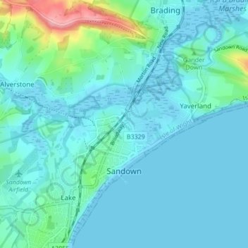
Nombre: Mapa topográfico Sandown, altitud, relieve.

Lugar: Sandown, Isle of Wight, England, United Kingdom (50.64936 -1.17610 50.67318 -1.10774)

Altitud media: 18 m

Altitud mínima: -2 m

Altitud máxima: 129 m

Otros mapas topográficos

Haga clic en un mapa para ver su topografía, su altitud y su relieve.

Arreton

United Kingdom > England > Isle of Wight

Altitud media: 50 m

Roud

United Kingdom > England > Isle of Wight > Godshill

Altitud media: 75 m

Cranmore

United Kingdom > England > Isle of Wight

Altitud media: 12 m

Winford

United Kingdom > England > Isle of Wight

Altitud media: 30 m

Niton

United Kingdom > England > Isle of Wight

Altitud media: 79 m

Newport

United Kingdom > England > Isle of Wight

Altitud media: 45 m

Gurnard

United Kingdom > England > Isle of Wight

Altitud media: 18 m

Binstead

United Kingdom > England > Isle of Wight > Ryde

Altitud media: 23 m

Bierley

United Kingdom > England > Isle of Wight > Whitwell

Altitud media: 105 m

Newport

United Kingdom > England > Isle of Wight

Altitud media: 45 m

Newport

United Kingdom > England > Isle of Wight

Altitud media: 45 m

Newport

United Kingdom > England > Isle of Wight

Altitud media: 45 m

Equípate para tu próxima aventura:

🧤Guantes Térmicos Táctiles - Protege tus manos sin dejar de usar tu GPS o móvil
🍳Sets de Cocina para Camping - Menaje ligero de aluminio para montaña
🧴Impermeabilizante para Botas - Spray protector para mantener tus pies secos en cualquier mapa
🧳Bolsas de compresión - Optimización del espacio
🏔️Equipamiento alta montaña - Material técnico para altitud

Como asociado de Amazon, este sitio gana comisiones por las compras que califican, sin ningún costo adicional para usted.