Geolocalizar

Mapa topográfico Freshwater

Haga clic en el mapa para ver la altitud.

👉 Easily get elevation data in JSON, GeoTIFF and KML formats using Elevation API
Gracias por apoyar a este sitio ❤️
Haz una donación

Acerca de este mapa

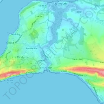
Nombre: Mapa topográfico Freshwater, altitud, relieve.

Lugar: Freshwater, Isle of Wight, England, United Kingdom (50.65151 -1.53881 50.70734 -1.46059)

Altitud media: 15 m

Altitud mínima: -4 m

Altitud máxima: 145 m

Otros mapas topográficos

Haga clic en un mapa para ver su topografía, su altitud y su relieve.

Arreton

United Kingdom > England > Isle of Wight

Altitud media: 50 m

Roud

United Kingdom > England > Isle of Wight > Godshill

Altitud media: 75 m

Cranmore

United Kingdom > England > Isle of Wight

Altitud media: 12 m

Winford

United Kingdom > England > Isle of Wight

Altitud media: 30 m

Niton

United Kingdom > England > Isle of Wight

Altitud media: 79 m

Newport

United Kingdom > England > Isle of Wight

Altitud media: 45 m

Gurnard

United Kingdom > England > Isle of Wight

Altitud media: 18 m

Binstead

United Kingdom > England > Isle of Wight > Ryde

Altitud media: 23 m

Bierley

United Kingdom > England > Isle of Wight > Whitwell

Altitud media: 105 m

Newport

United Kingdom > England > Isle of Wight

Altitud media: 45 m

Newport

United Kingdom > England > Isle of Wight

Altitud media: 45 m

Newport

United Kingdom > England > Isle of Wight

Altitud media: 45 m

Equípate para tu próxima aventura:

🛏️Sacos de dormir - Sacos térmicos para montaña
🚲Soportes de Móvil para Manillar - Visualiza tus mapas topográficos mientras pedaleas
🚲Guantes de Ciclismo MTB - Protección y agarre en el manillar
🧥Chaquetas Impermeables Hombre - Protección total contra la lluvia y el viento (Gore-Tex y más)
🪜Cordinos de seguridad - Apoyo técnico en montaña

Como asociado de Amazon, este sitio gana comisiones por las compras que califican, sin ningún costo adicional para usted.