
Haz una donación
Equípate para tu próxima aventura:
Como asociado de Amazon, este sitio gana comisiones por las compras que califican, sin ningún costo adicional para usted.
Mapa topográfico Hopa
Haga clic en el mapa para ver la altitud.
Haz una donación
Equípate para tu próxima aventura:
Como asociado de Amazon, este sitio gana comisiones por las compras que califican, sin ningún costo adicional para usted.
Acerca de este mapa
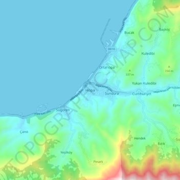
Nombre: Mapa topográfico Hopa, altitud, relieve.
Lugar: Hopa, Artvin, Black Sea Region, 08600, Turkey (41.34875 41.37816 41.42875 41.45816)
Altitud media: 168 m
Altitud mínima: 0 m
Altitud máxima: 1.060 m
Haz una donación
Equípate para tu próxima aventura:
Como asociado de Amazon, este sitio gana comisiones por las compras que califican, sin ningún costo adicional para usted.
Otros mapas topográficos
Haga clic en un mapa para ver su topografía, su altitud y su relieve.
Haz una donación
Equípate para tu próxima aventura:
Como asociado de Amazon, este sitio gana comisiones por las compras que califican, sin ningún costo adicional para usted.
Antalya
The highest point of the Taurus mountains is Akdağ at an altitude of 3025 metres. Located to the northwest of the city centre and at a distance of 50 km (31 mi) is the Saklıkent ski and recreation centre on Beydağları. Here one can ski and then go down to the shore and into the sea during the months of…
Altitud media: 644 m
Bolvadin
Bolvadin (Ancient Greek: Πολύβοτον/Πολύβοτος and Latin: Polybotum/Polybotus) is a city of Afyonkarahisar Province in Turkey. It is the seat of Bolvadin District. Bolvadin district has a total population of 45,468 according to the 2024 census. It has an altitude of 1,016 m. The mayor is Derviş Aynaci (MHP).
Altitud media: 1.202 m
Haz una donación
Equípate para tu próxima aventura:
Como asociado de Amazon, este sitio gana comisiones por las compras que califican, sin ningún costo adicional para usted.
Haz una donación
Equípate para tu próxima aventura:
Como asociado de Amazon, este sitio gana comisiones por las compras que califican, sin ningún costo adicional para usted.
Haz una donación
Equípate para tu próxima aventura:
Como asociado de Amazon, este sitio gana comisiones por las compras que califican, sin ningún costo adicional para usted.
Anatolia
Anatolia (Turkish: Anadolu), also known as Asia Minor, is a peninsula in West Asia that makes up the majority of the land area of Turkey. It is the westernmost protrusion of Asia and is geographically bounded by the Mediterranean Sea to the south, the Aegean Sea to the west, the Turkish Straits to the…
Altitud media: 518 m
Haz una donación
Equípate para tu próxima aventura:
Como asociado de Amazon, este sitio gana comisiones por las compras que califican, sin ningún costo adicional para usted.
Kaş
As the tenth largest district of Antalya as of 2021, Kaş is on a hill running down to the Turquoise Coast of southwestern Turkey. The district has a typical Mediterranean climate of hot, dry summers and mild, wet winters, which allows the growth of oranges, lemons and bananas. The lowland areas are also…
Altitud media: 837 m
Taurus Mountains
The mountains have a Mediterranean climate, with dry summers and rainy winters. Temperatures vary with elevation, with warm winters on the lower coastal slopes and cold winters in the high mountains and in the interior.
Altitud media: 828 m
İzmit
The city is mostly built on hill slopes because of the cramped area, while flat plains surround the gulf, near the sea. This topographic structure divided the city into two parts. The first was created on flat plains, where the city center is located. The railway and highway networks pass from this area which…
Altitud media: 194 m
Haz una donación
Equípate para tu próxima aventura:
Como asociado de Amazon, este sitio gana comisiones por las compras que califican, sin ningún costo adicional para usted.
Kaş
As the tenth largest district of Antalya as of 2021, Kaş is on a hill running down to the Turquoise Coast of southwestern Turkey. The district has a typical Mediterranean climate of hot, dry summers and mild, wet winters, which allows the growth of oranges, lemons and bananas. The lowland areas are also…
Altitud media: 837 m
Haz una donación
Equípate para tu próxima aventura:
Como asociado de Amazon, este sitio gana comisiones por las compras que califican, sin ningún costo adicional para usted.
Prince Islands
All islands contain hills, the highest being Büyükada's Aya Yorgi Hill with 203 meters of elevation.
Altitud media: 12 m
Haz una donación
Equípate para tu próxima aventura:
Como asociado de Amazon, este sitio gana comisiones por las compras que califican, sin ningún costo adicional para usted.
Haz una donación
Equípate para tu próxima aventura:
Como asociado de Amazon, este sitio gana comisiones por las compras que califican, sin ningún costo adicional para usted.
Sivas
The city, which lies at an elevation of 1,278 metres (4,193 ft) in the broad valley of the Kızılırmak river, is a moderately-sized trade centre and industrial city, although the economy has traditionally been based on agriculture. Rail repair shops and a thriving manufacturing industry of rugs, bricks,…
Altitud media: 1.482 m
Haz una donación
Equípate para tu próxima aventura:
Como asociado de Amazon, este sitio gana comisiones por las compras que califican, sin ningún costo adicional para usted.
Haz una donación
Equípate para tu próxima aventura:
Como asociado de Amazon, este sitio gana comisiones por las compras que califican, sin ningún costo adicional para usted.
Haz una donación
Equípate para tu próxima aventura:
Como asociado de Amazon, este sitio gana comisiones por las compras que califican, sin ningún costo adicional para usted.
Haz una donación
Equípate para tu próxima aventura:
Como asociado de Amazon, este sitio gana comisiones por las compras que califican, sin ningún costo adicional para usted.
Haz una donación
Equípate para tu próxima aventura:
Como asociado de Amazon, este sitio gana comisiones por las compras que califican, sin ningún costo adicional para usted.
Bergama
Kozak Plateau (Kozak Yaylası) is a high plain at an altitude varying between 500 and 1,000 metres (1,600 and 3,300 feet) and starting at a distance of 20 km (12 mi) from Bergama center in the northern direction. The plain is a favorite regional excursion area, famed for its hand-made textile products and pine…
Altitud media: 323 m
Kaş
As the tenth most populous district of Antalya as of 2022, Kaş is on a hill running down to the Turquoise Coast of southwestern Turkey. The district has a typical Mediterranean climate of hot, dry summers and mild, wet winters, which allows the growth of oranges, lemons and bananas. The lowland areas are also…
Altitud media: 837 m
Haz una donación
Equípate para tu próxima aventura:
Como asociado de Amazon, este sitio gana comisiones por las compras que califican, sin ningún costo adicional para usted.
Haz una donación
Equípate para tu próxima aventura:
Como asociado de Amazon, este sitio gana comisiones por las compras que califican, sin ningún costo adicional para usted.
Antakya
Antakya's climate is classified as hot-summer Mediterranean (Köppen: Csa) or dry-summer humid subtropical (Trewartha: Cf or wet Cs). The city experiences hot, dry summers, and mild, wet winters; though its higher altitude allows for lower temperatures than the coast.
Altitud media: 385 m
Haz una donación
Equípate para tu próxima aventura:
Como asociado de Amazon, este sitio gana comisiones por las compras que califican, sin ningún costo adicional para usted.
Haz una donación
Equípate para tu próxima aventura:
Como asociado de Amazon, este sitio gana comisiones por las compras que califican, sin ningún costo adicional para usted.
Haz una donación
Equípate para tu próxima aventura:
Como asociado de Amazon, este sitio gana comisiones por las compras que califican, sin ningún costo adicional para usted.
Haz una donación
Equípate para tu próxima aventura:
Como asociado de Amazon, este sitio gana comisiones por las compras que califican, sin ningún costo adicional para usted.
Haz una donación
Equípate para tu próxima aventura:
Como asociado de Amazon, este sitio gana comisiones por las compras que califican, sin ningún costo adicional para usted.
Haz una donación
Equípate para tu próxima aventura:
Como asociado de Amazon, este sitio gana comisiones por las compras que califican, sin ningún costo adicional para usted.
Haz una donación
Equípate para tu próxima aventura:
Como asociado de Amazon, este sitio gana comisiones por las compras que califican, sin ningún costo adicional para usted.
Erdemli
Erdemli is a quiet rural district where the people are conservative, and is traditionally a stronghold of Turkish nationalist politicians; however some departments of Mersin University are opening branches here which will surely have an effect on the cultural and social life of Erdemli in the future. There is…
Altitud media: 966 m
Haz una donación
Equípate para tu próxima aventura:
Como asociado de Amazon, este sitio gana comisiones por las compras que califican, sin ningún costo adicional para usted.
Bağcılar
Bağcılar is located on the European side of Istanbul, within the service boundaries of Istanbul Metropolitan Municipality. Its area is 22 km2 (8.5 sq mi). The district is now known as an immigrant quarter. It lies between E-5 and TEM. In the south Bahçelievler, in the west Küçükçekmece, in the northwest…
Altitud media: 85 m
Haz una donación
Equípate para tu próxima aventura:
Como asociado de Amazon, este sitio gana comisiones por las compras que califican, sin ningún costo adicional para usted.