
Haz una donación
Equípate para tu próxima aventura:
Como asociado de Amazon, este sitio gana comisiones por las compras que califican, sin ningún costo adicional para usted.
Mapa topográfico Mount Piapayungan
Haga clic en el mapa para ver la altitud.
Haz una donación
Equípate para tu próxima aventura:
Como asociado de Amazon, este sitio gana comisiones por las compras que califican, sin ningún costo adicional para usted.
Mount Piapayungan
Mount Ragang, also called Mount Piapayungan and Blue Mountain by the local people, is an active stratovolcano on Mindanao island in the Philippines. With an elevation of 2,815 metres (9,236 ft), it is the seventh highest mountain in the Philippines and the highest point in the Lanao del Sur province.
Haz una donación
Equípate para tu próxima aventura:
Como asociado de Amazon, este sitio gana comisiones por las compras que califican, sin ningún costo adicional para usted.
Acerca de este mapa
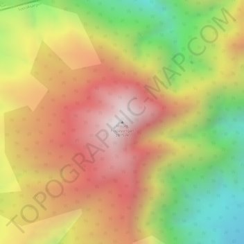
Nombre: Mapa topográfico Mount Piapayungan, altitud, relieve.
Lugar: Mount Piapayungan, Lanao del Sur, Bangsamoro, Philippines (7.69081 124.50718 7.69091 124.50728)
Altitud media: 2.394 m
Altitud mínima: 1.884 m
Altitud máxima: 2.781 m
Haz una donación
Equípate para tu próxima aventura:
Como asociado de Amazon, este sitio gana comisiones por las compras que califican, sin ningún costo adicional para usted.
Otros mapas topográficos
Haga clic en un mapa para ver su topografía, su altitud y su relieve.
Lake Lanao
The lake has great hydroelectric potential due to its 700 meter elevation, and as such, in 1950, the Philippines National Power Corporation (NAPOCOR) began the construction of a series of hydroelectric plants titled Agus I – Agus VII along the Agus River system, which generates 70% of the electricity used by…
Altitud media: 787 m
Marawi City
Marawi is located upon the shores of Lake Lanao. It is primarily inhabited by the Maranao people. The city is also called the "Summer Capital of the South" due to its higher elevation and cooler climate, a nickname it shares with Malaybalay.
Altitud media: 707 m
Haz una donación
Equípate para tu próxima aventura:
Como asociado de Amazon, este sitio gana comisiones por las compras que califican, sin ningún costo adicional para usted.
Marawi
Marawi is located upon the shores of Lake Lanao. It is primarily inhabited by the Maranao people. The city is also called the "Summer Capital of the South" due to its higher elevation and cooler climate, a nickname it shares with Malaybalay.
Altitud media: 708 m
Marawi
Marawi is located upon the shores of Lake Lanao. It is primarily inhabited by the Maranao people. The city is also called the "Summer Capital of the South" due to its higher elevation and cooler climate, a nickname it shares with Malaybalay.
Altitud media: 708 m
Marawi City
Marawi is located upon the shores of Lake Lanao. It is primarily inhabited by the Maranao people. The city is also called the "Summer Capital of the South" due to its higher elevation and cooler climate, a nickname it shares with Malaybalay.
Altitud media: 707 m
Haz una donación
Equípate para tu próxima aventura:
Como asociado de Amazon, este sitio gana comisiones por las compras que califican, sin ningún costo adicional para usted.