
Haz una donación
Equípate para tu próxima aventura:
Como asociado de Amazon, este sitio gana comisiones por las compras que califican, sin ningún costo adicional para usted.
Mapa topográfico Seven Devils
Haga clic en el mapa para ver la altitud.
Haz una donación
Equípate para tu próxima aventura:
Como asociado de Amazon, este sitio gana comisiones por las compras que califican, sin ningún costo adicional para usted.
Acerca de este mapa
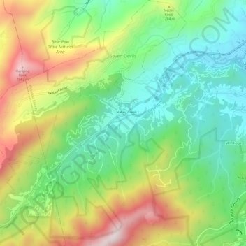
Nombre: Mapa topográfico Seven Devils, altitud, relieve.
Lugar: Seven Devils, Watauga County, North Carolina, United States (36.11835 -81.83952 36.16695 -81.78408)
Altitud media: 1.175 m
Altitud mínima: 913 m
Altitud máxima: 1.589 m
Haz una donación
Equípate para tu próxima aventura:
Como asociado de Amazon, este sitio gana comisiones por las compras que califican, sin ningún costo adicional para usted.
Otros mapas topográficos
Haga clic en un mapa para ver su topografía, su altitud y su relieve.
Valle Crucis
United States > North Carolina > Watauga County
Valle Crucis is located at the banks of Dutch Creek and Watauga River, at an elevation of 2,677 feet (816 m) above sea level. To its north and east is Tester Mountain and to its south and west is Valle Mountain. The community is also within the Pisgah National Forest boundary, which limits some development in…
Altitud media: 904 m
Haz una donación
Equípate para tu próxima aventura:
Como asociado de Amazon, este sitio gana comisiones por las compras que califican, sin ningún costo adicional para usted.
Haz una donación
Equípate para tu próxima aventura:
Como asociado de Amazon, este sitio gana comisiones por las compras que califican, sin ningún costo adicional para usted.
Rich Mountain
United States > North Carolina > Watauga County
Rich Mountain is a mountain located in the North Carolina High Country, roughly 3 miles (4.8 km) northwest of the town of Boone. Its elevation reaches 4,748 feet (1,447 m).
Altitud media: 1.214 m
Elk Knob
United States > North Carolina > Watauga County
Elk Knob is a mountain in the North Carolina High Country, north of the community of Meat Camp. Its elevation reaches 5,538 feet (1,688 m).
Altitud media: 1.362 m
Haz una donación
Equípate para tu próxima aventura:
Como asociado de Amazon, este sitio gana comisiones por las compras que califican, sin ningún costo adicional para usted.
Rich Mountain
United States > North Carolina > Watauga County
Rich Mountain is a mountain located in the North Carolina High Country, roughly 3 miles (4.8 km) northwest of the town of Boone. Its elevation reaches 4,748 feet (1,447 m).
Altitud media: 1.214 m
Haz una donación
Equípate para tu próxima aventura:
Como asociado de Amazon, este sitio gana comisiones por las compras que califican, sin ningún costo adicional para usted.
Haz una donación
Equípate para tu próxima aventura:
Como asociado de Amazon, este sitio gana comisiones por las compras que califican, sin ningún costo adicional para usted.
Valle Crucis
United States > North Carolina > Watauga County
Valle Crucis is located at the banks of Dutch Creek and Watauga River, at an elevation of 2,677 feet (816 m) above sea level. To its north and east is Tester Mountain and to its south and west is Valle Mountain. The community is also within the Pisgah National Forest boundary, which limits some development in…
Altitud media: 904 m
Haz una donación
Equípate para tu próxima aventura:
Como asociado de Amazon, este sitio gana comisiones por las compras que califican, sin ningún costo adicional para usted.
Beech Mountain
United States > North Carolina > Watauga County > Beech Mountain
Altitud media: 1.264 m
Sorrento Skies
United States > North Carolina > Watauga County > Sorrento Skies
Altitud media: 1.069 m
Haz una donación
Equípate para tu próxima aventura:
Como asociado de Amazon, este sitio gana comisiones por las compras que califican, sin ningún costo adicional para usted.
Boone
United States > North Carolina > Watauga County > Boone > Boone
Boone is located at 36°12′41″N 81°40′7″W / 36.21139°N 81.66861°W / 36.21139; -81.66861 (36.211364, −81.668657) and has an elevation of 3,333 feet (1015.9 m) above sea level. An earlier survey gave the elevation as 3,332 ft and since then it has been published as having an elevation of…
Altitud media: 977 m