
Haz una donación
Equípate para tu próxima aventura:
Como asociado de Amazon, este sitio gana comisiones por las compras que califican, sin ningún costo adicional para usted.
Mapa topográfico Rominger
Haga clic en el mapa para ver la altitud.
Haz una donación
Equípate para tu próxima aventura:
Como asociado de Amazon, este sitio gana comisiones por las compras que califican, sin ningún costo adicional para usted.
Acerca de este mapa
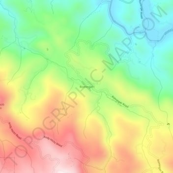
Nombre: Mapa topográfico Rominger, altitud, relieve.
Altitud media: 1.068 m
Altitud mínima: 791 m
Altitud máxima: 1.415 m
Haz una donación
Equípate para tu próxima aventura:
Como asociado de Amazon, este sitio gana comisiones por las compras que califican, sin ningún costo adicional para usted.
Otros mapas topográficos
Haga clic en un mapa para ver su topografía, su altitud y su relieve.
Boone
United States > North Carolina > Watauga County
Boone, located in Watauga County, North Carolina, is set within the rugged Appalachian Mountains, specifically the Blue Ridge range. With an elevation of approximately 3,300 feet (1,016 meters), it stands as one of the highest towns of its size in the eastern United States. The terrain is dominated by steep…
Altitud media: 1.069 m
Blowing Rock
United States > North Carolina > Watauga County
Blowing Rock is characterized by its rugged and varied topography, nestled within the southern reaches of the Blue Ridge Mountains. The town itself is situated on a prominent ridge, with elevations ranging from approximately 3,300 to 3,600 feet, creating dramatic landscapes that feature steep slopes, rocky…
Altitud media: 1.032 m
Blue Ridge Parkway
United States > North Carolina > Watauga County
The parkway has been the most visited unit of the National Park System every year since 1946 except four (1949, 2013, 2016 and 2019). Land on either side of the road is owned and maintained by the National Park Service, and in many places parkway land is bordered by United States Forest Service property. There…
Altitud media: 504 m
Blue Ridge Parkway
United States > North Carolina > Watauga County
The parkway has been the most visited unit of the National Park System every year since 1946 except four (1949, 2013, 2016 and 2019).[4][5] Land on either side of the road is owned and maintained by the National Park Service, and in many places parkway land is bordered by United States Forest Service property.…
Altitud media: 504 m
Haz una donación
Equípate para tu próxima aventura:
Como asociado de Amazon, este sitio gana comisiones por las compras que califican, sin ningún costo adicional para usted.
Beech Mountain
United States > North Carolina > Watauga County
Beech Mountain is a town in both Avery and Watauga counties in the U.S. state of North Carolina. As of the 2010 census, the town population was 320. The town is located atop Beech Mountain and is the highest town east of the Rocky Mountains at 5,506 ft (1,678 m) in elevation. The nearest municipality at a…
Altitud media: 1.267 m
Haz una donación
Equípate para tu próxima aventura:
Como asociado de Amazon, este sitio gana comisiones por las compras que califican, sin ningún costo adicional para usted.
Boone
United States > North Carolina > Watauga County
Boone is located at 36°12′41″N 81°40′7″W / 36.21139°N 81.66861°W / 36.21139; -81.66861 (36.211364, −81.668657) and has an elevation of 3,333 feet (1015.9 m) above sea level. An earlier survey gave the elevation as 3,332 ft and since then it has been published as having an elevation of…
Altitud media: 1.069 m
Boone
United States > North Carolina > Watauga County
Boone has an elevation of 3,333 feet (1,016 m) above sea level. An earlier survey gave the elevation as 3,332 ft and since then it has been published as 3,333 ft (1,016 m). Boone has the highest elevation of any town of its size (over 10,000 population) east of the Mississippi River. As such, Boone features,…
Altitud media: 1.069 m
Blowing Rock
United States > North Carolina > Watauga County
The climate in the area can be described as warm-summer humid continental (Dfb), or highland subtropical climate (Cfb) depending on the isotherm used; Köppen Climate Classification. This results in an unusual climate compared to the rest of North Carolina; the town's elevation of 3,500 to 3,600 feet (1,100 to…
Altitud media: 1.032 m
Haz una donación
Equípate para tu próxima aventura:
Como asociado de Amazon, este sitio gana comisiones por las compras que califican, sin ningún costo adicional para usted.
Moses H Cone Memorial Park
United States > North Carolina > Watauga County > Blowing Rock
Altitud media: 1.121 m
Boone
United States > North Carolina > Watauga County
Boone is located at 36°12′41″N 81°40′7″W / 36.21139°N 81.66861°W / 36.21139; -81.66861 (36.211364, −81.668657) and has an elevation of 3,333 feet (1015.9 m) above sea level. An earlier survey gave the elevation as 3,332 ft and since then it has been published as having an elevation of…
Altitud media: 1.069 m