
Haz una donación
Equípate para tu próxima aventura:
Como asociado de Amazon, este sitio gana comisiones por las compras que califican, sin ningún costo adicional para usted.
Mapa topográfico Xhariep District Municipality
Haga clic en el mapa para ver la altitud.
Haz una donación
Equípate para tu próxima aventura:
Como asociado de Amazon, este sitio gana comisiones por las compras que califican, sin ningún costo adicional para usted.
Acerca de este mapa
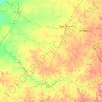
Nombre: Mapa topográfico Xhariep District Municipality, altitud, relieve.
Lugar: Xhariep District Municipality, Free State, South Africa (-30.69408 24.34662 -28.82826 27.41033)
Altitud media: 1.371 m
Altitud mínima: 1.010 m
Altitud máxima: 2.371 m
Haz una donación
Equípate para tu próxima aventura:
Como asociado de Amazon, este sitio gana comisiones por las compras que califican, sin ningún costo adicional para usted.
Otros mapas topográficos
Haga clic en un mapa para ver su topografía, su altitud y su relieve.
Bloemfontein
South Africa > Free State > Mangaung Metropolitan Municipality
Situated at an elevation of 1,395 m (4,577 ft) above sea level, the city is home to approximately 520,000 residents and forms part of the Mangaung Metropolitan Municipality which has a population of 747,431. It was one of the host cities for the 2010 FIFA World Cup.
Altitud media: 1.374 m
Phuthaditjhaba
South Africa > Free State > Thabo Mofutsanyana District Municipality > Maluti-a-Phofung Local Municipality
Altitud media: 1.736 m
Vaal Dam
South Africa > Free State > Fezile Dabi District Municipality > Metsimaholo Local Municipality > Deneysville
Altitud media: 1.481 m
Bethlehem
South Africa > Free State > Thabo Mofutsanyana District Municipality > Dihlabeng Local Municipality
The city lies at an altitude of 1,700 metres (5,600 ft) and this contributes to its cool climate with frosty winters and mild summers. The average annual temperature is around 14 °C (57 °F).
Altitud media: 1.675 m
Haz una donación
Equípate para tu próxima aventura:
Como asociado de Amazon, este sitio gana comisiones por las compras que califican, sin ningún costo adicional para usted.
Welkom
South Africa > Free State > Lejweleputswa District Municipality
Koppie Alleen is the only hill near Welkom and therefore is aptly named for its oddity. The terrain elevation above sea level is 1435 metres. The largest water catchment is the Sand River to the south-east of Welkom in Virginia's direction. Large saline pans such as Flamingo Pan and Theronia Pan are situated…
Altitud media: 1.341 m
Fouriesburg
South Africa > Free State > Thabo Mofutsanyana District Municipality > Dihlabeng Local Municipality
Altitud media: 1.745 m
Reitz
South Africa > Free State > Thabo Mofutsanyana District Municipality > Nketoana Local Municipality
Reitz is located in the north-eastern part of the Free State province, 300 kilometres (190 mi) north-east of Bloemfontein and 180 kilometres (110 mi) south of Johannesburg. It lies roughly halfway between the towns of Bethlehem and Frankfort, at an elevation of 1,630 metres (5,350 ft).
Altitud media: 1.648 m
Sasolburg
South Africa > Free State > Fezile Dabi District Municipality > Metsimaholo Local Municipality
Sasolburg is at a high altitude with a fairly dry climate and large seasonal temperature variation. It is situated on the banks of the Vaal River, which separates the Free State from the former Transvaal Province, and is not far from the Vaal Dam where excellent windsurfing spots can be found.
Altitud media: 1.469 m
Haz una donación
Equípate para tu próxima aventura:
Como asociado de Amazon, este sitio gana comisiones por las compras que califican, sin ningún costo adicional para usted.
Kroonstad
South Africa > Free State > Fezile Dabi District Municipality > Moqhaka Local Municipality
Altitud media: 1.380 m
Vrede
South Africa > Free State > Thabo Mofutsanyana District Municipality > Phumelela Local Municipality
Altitud media: 1.678 m
Bothaville
South Africa > Free State > Lejweleputswa District Municipality > Nala Local Municipality
Altitud media: 1.287 m
Parys
South Africa > Free State > Fezile Dabi District Municipality > Ngwathe Local Municipality
Altitud media: 1.408 m
Haz una donación
Equípate para tu próxima aventura:
Como asociado de Amazon, este sitio gana comisiones por las compras que califican, sin ningún costo adicional para usted.
Ficksburg
South Africa > Free State > Thabo Mofutsanyana District Municipality > Setsoto Local Municipality
Altitud media: 1.617 m
Welkom
South Africa > Free State > Lejweleputswa District Municipality
Koppie Alleen is the only hill near Welkom and therefore is aptly named for its oddity. The terrain elevation above sea level is 1435 metres. The largest water catchment is the Sand River to the south-east of Welkom in Virginia's direction. Large saline pans such as Flamingo Pan and Theronia Pan are situated…
Altitud media: 1.341 m
Haz una donación
Equípate para tu próxima aventura:
Como asociado de Amazon, este sitio gana comisiones por las compras que califican, sin ningún costo adicional para usted.
Clarens
South Africa > Free State > Thabo Mofutsanyana District Municipality > Dihlabeng Local Municipality
Altitud media: 1.874 m
Viljoenskroon
South Africa > Free State > Fezile Dabi District Municipality > Moqhaka Local Municipality
Altitud media: 1.335 m
Koppies Dam
South Africa > Free State > Fezile Dabi District Municipality > Ngwathe Local Municipality
Altitud media: 1.399 m
Zastron
South Africa > Free State > Xhariep District Municipality > Mohokare Local Municipality
Altitud media: 1.719 m
Haz una donación
Equípate para tu próxima aventura:
Como asociado de Amazon, este sitio gana comisiones por las compras que califican, sin ningún costo adicional para usted.
Hoopstad
South Africa > Free State > Lejweleputswa District Municipality > Tswelopele Local Municipality
Altitud media: 1.251 m
Mont Pelaan
South Africa > Free State > Thabo Mofutsanyana District Municipality > Phumelela Local Municipality
Altitud media: 1.960 m
Hlohlolwane (Clocolan)
South Africa > Free State > Thabo Mofutsanyana District Municipality > Setsoto Local Municipality
Altitud media: 1.593 m
Bultfontein
South Africa > Free State > Lejweleputswa District Municipality > Tswelopele Local Municipality
Altitud media: 1.326 m
Haz una donación
Equípate para tu próxima aventura:
Como asociado de Amazon, este sitio gana comisiones por las compras que califican, sin ningún costo adicional para usted.
Harmony
South Africa > Free State > Lejweleputswa District Municipality > Matjhabeng Local Municipality
Altitud media: 1.333 m
Deneysville
South Africa > Free State > Fezile Dabi District Municipality > Metsimaholo Local Municipality
Altitud media: 1.496 m
Winnie Mandela (Brandfort)
South Africa > Free State > Lejweleputswa District Municipality > Masilonyana Local Municipality
Altitud media: 1.403 m
Virginia
South Africa > Free State > Lejweleputswa District Municipality > Matjhabeng Local Municipality
Altitud media: 1.326 m
Haz una donación
Equípate para tu próxima aventura:
Como asociado de Amazon, este sitio gana comisiones por las compras que califican, sin ningún costo adicional para usted.
Ladybrand
South Africa > Free State > Thabo Mofutsanyana District Municipality > Mantsopa Local Municipality
Altitud media: 1.634 m
Reddersburg
South Africa > Free State > Xhariep District Municipality > Kopanong Local Municipality
Altitud media: 1.423 m
Renoster River
South Africa > Free State > Thabo Mofutsanyana District Municipality > Nketoana Local Municipality
Altitud media: 1.587 m
Theunissen
South Africa > Free State > Lejweleputswa District Municipality > Masilonyana Local Municipality
Altitud media: 1.395 m
Haz una donación
Equípate para tu próxima aventura:
Como asociado de Amazon, este sitio gana comisiones por las compras que califican, sin ningún costo adicional para usted.
Odendaalsrus
South Africa > Free State > Lejweleputswa District Municipality > Matjhabeng Local Municipality
Altitud media: 1.336 m
Hertzogville
South Africa > Free State > Lejweleputswa District Municipality > Tokologo Local Municipality
Altitud media: 1.285 m
Wesselsbron
South Africa > Free State > Lejweleputswa District Municipality > Nala Local Municipality
Altitud media: 1.297 m
Verkeerdevlei
South Africa > Free State > Lejweleputswa District Municipality > Masilonyana Local Municipality
Altitud media: 1.474 m
Haz una donación
Equípate para tu próxima aventura:
Como asociado de Amazon, este sitio gana comisiones por las compras que califican, sin ningún costo adicional para usted.
Rouxville
South Africa > Free State > Xhariep District Municipality > Mohokare Local Municipality
Altitud media: 1.518 m
Swartkrans
South Africa > Free State > Thabo Mofutsanyana District Municipality > Dihlabeng Local Municipality
Altitud media: 2.036 m
Marquard
South Africa > Free State > Thabo Mofutsanyana District Municipality > Setsoto Local Municipality
Altitud media: 1.512 m
Bloemhof Dam
South Africa > Free State > Lejweleputswa District Municipality > Tswelopele Local Municipality
Altitud media: 1.228 m
Haz una donación
Equípate para tu próxima aventura:
Como asociado de Amazon, este sitio gana comisiones por las compras que califican, sin ningún costo adicional para usted.
Wilge River
South Africa > Free State > Thabo Mofutsanyana District Municipality > Maluti-a-Phofung Local Municipality
Altitud media: 1.739 m
Koeberg
South Africa > Free State > Thabo Mofutsanyana District Municipality > Dihlabeng Local Municipality
Altitud media: 2.167 m
Mabula
South Africa > Free State > Thabo Mofutsanyana District Municipality > Mantsopa Local Municipality
Altitud media: 1.766 m
Haz una donación
Equípate para tu próxima aventura:
Como asociado de Amazon, este sitio gana comisiones por las compras que califican, sin ningún costo adicional para usted.
Smithfield
South Africa > Free State > Xhariep District Municipality > Mohokare Local Municipality
Altitud media: 1.441 m
Tierpoort
South Africa > Free State > Xhariep District Municipality > Kopanong Local Municipality
Altitud media: 1.301 m
Mount Morkel
South Africa > Free State > Thabo Mofutsanyana District Municipality > Dihlabeng Local Municipality
Altitud media: 1.849 m
HJ Joel Nature Reserve
South Africa > Free State > Lejweleputswa District Municipality > Masilonyana Local Municipality
Altitud media: 1.386 m
Haz una donación
Equípate para tu próxima aventura:
Como asociado de Amazon, este sitio gana comisiones por las compras que califican, sin ningún costo adicional para usted.
Fauresmith
South Africa > Free State > Xhariep District Municipality > Kopanong Local Municipality
Altitud media: 1.411 m
Edenville
South Africa > Free State > Fezile Dabi District Municipality > Ngwathe Local Municipality
Altitud media: 1.514 m
Erfenis Dam
South Africa > Free State > Lejweleputswa District Municipality > Masilonyana Local Municipality
Altitud media: 1.356 m
Bohlokong
South Africa > Free State > Thabo Mofutsanyana District Municipality > Dihlabeng Local Municipality
Altitud media: 1.633 m
Haz una donación
Equípate para tu próxima aventura:
Como asociado de Amazon, este sitio gana comisiones por las compras que califican, sin ningún costo adicional para usted.
Van Stadensrus
South Africa > Free State > Xhariep District Municipality > Naledi Local Municipality
Altitud media: 1.479 m
Heilbron
South Africa > Free State > Fezile Dabi District Municipality > Ngwathe Local Municipality
Altitud media: 1.559 m
Elands River
South Africa > Free State > Thabo Mofutsanyana District Municipality > Maluti-a-Phofung Local Municipality
Altitud media: 1.638 m
Haz una donación
Equípate para tu próxima aventura:
Como asociado de Amazon, este sitio gana comisiones por las compras que califican, sin ningún costo adicional para usted.
Driekloof Dam
South Africa > Free State > Thabo Mofutsanyana District Municipality > Maluti-a-Phofung Local Municipality
Altitud media: 1.743 m
Lindley
South Africa > Free State > Thabo Mofutsanyana District Municipality > Nketoana Local Municipality
Altitud media: 1.540 m
Highveld
South Africa > Free State > Lejweleputswa District Municipality > Matjhabeng Local Municipality
The Highveld (Afrikaans: Hoëveld, pronounced [ˈɦuəfælt], lit. 'High Field') is the portion of the South African inland plateau which has an altitude above roughly 1,500 m (4,900 ft), but below 2,100 m (6,900 ft), thus excluding the Lesotho mountain regions to the south-east of the Highveld. It is home…
Altitud media: 1.380 m
Bethlehem
South Africa > Free State > Thabo Mofutsanyana District Municipality > Dihlabeng Local Municipality
The city lies at an altitude of 1,700 metres (5,600 ft), which contributes to its cool climate, with frosty winters and mild summers. The average annual temperature is around 14 °C (57 °F).
Altitud media: 1.675 m
Haz una donación
Equípate para tu próxima aventura:
Como asociado de Amazon, este sitio gana comisiones por las compras que califican, sin ningún costo adicional para usted.
Sterkfontein Dam
South Africa > Free State > Thabo Mofutsanyana District Municipality > Maluti-a-Phofung Local Municipality
Altitud media: 1.677 m
Bothaville
South Africa > Free State > Lejweleputswa District Municipality > Nala Local Municipality
Altitud media: 1.287 m
Heilbron
South Africa > Free State > Fezile Dabi District Municipality > Ngwathe Local Municipality
Altitud media: 1.559 m
Kroonstad
South Africa > Free State > Fezile Dabi District Municipality > Moqhaka Local Municipality
Altitud media: 1.380 m
Haz una donación
Equípate para tu próxima aventura:
Como asociado de Amazon, este sitio gana comisiones por las compras que califican, sin ningún costo adicional para usted.
Heilbron
South Africa > Free State > Fezile Dabi District Municipality > Ngwathe Local Municipality
Altitud media: 1.559 m
Parys
South Africa > Free State > Fezile Dabi District Municipality > Ngwathe Local Municipality
Altitud media: 1.408 m
Sasolburg
South Africa > Free State > Fezile Dabi District Municipality > Metsimaholo Local Municipality
Sasolburg is at a high altitude with a fairly dry climate and large seasonal temperature variation. It is situated on the banks of the Vaal River, which separates the Free State from the former Transvaal Province, and is not far from the Vaal Dam where excellent windsurfing spots can be found.
Altitud media: 1.469 m
Ficksburg
South Africa > Free State > Thabo Mofutsanyana District Municipality > Setsoto Local Municipality
Altitud media: 1.617 m
Haz una donación
Equípate para tu próxima aventura:
Como asociado de Amazon, este sitio gana comisiones por las compras que califican, sin ningún costo adicional para usted.
Renoster River
South Africa > Free State > Thabo Mofutsanyana District Municipality > Nketoana Local Municipality > Petrus Steyn
Altitud media: 1.698 m
Bronville
South Africa > Free State > Lejweleputswa District Municipality > Matjhabeng Local Municipality
Altitud media: 1.365 m
Vaal Dam
South Africa > Free State > Fezile Dabi District Municipality > Metsimaholo Local Municipality > Deneysville
Altitud media: 1.481 m
Welkom
South Africa > Free State > Lejweleputswa District Municipality
Koppie Alleen is the only hill near Welkom and therefore is aptly named for its oddity. The terrain elevation above sea level is 1435 metres. The largest water catchment is the Sand River to the south-east of Welkom in Virginia's direction. Large saline pans such as Flamingo Pan and Theronia Pan are situated…
Altitud media: 1.341 m
Haz una donación
Equípate para tu próxima aventura:
Como asociado de Amazon, este sitio gana comisiones por las compras que califican, sin ningún costo adicional para usted.
Vaal Dam
South Africa > Free State > Fezile Dabi District Municipality > Metsimaholo Local Municipality > Deneysville
Altitud media: 1.481 m
Welkom
South Africa > Free State > Lejweleputswa District Municipality
Koppie Alleen is the only hill near Welkom and therefore is aptly named for its oddity. The terrain elevation above sea level is 1435 metres. The largest water catchment is the Sand River to the south-east of Welkom in Virginia's direction. Large saline pans such as Flamingo Pan and Theronia Pan are situated…
Altitud media: 1.341 m
Bothaville
South Africa > Free State > Lejweleputswa District Municipality > Nala Local Municipality
Altitud media: 1.287 m
Koffiefontein
South Africa > Free State > Xhariep District Municipality > Letsemeng Local Municipality
Altitud media: 1.203 m
Haz una donación
Equípate para tu próxima aventura:
Como asociado de Amazon, este sitio gana comisiones por las compras que califican, sin ningún costo adicional para usted.
Jacobsdal
South Africa > Free State > Xhariep District Municipality > Letsemeng Local Municipality
Altitud media: 1.147 m
Bloemfontein
South Africa > Free State > Mangaung Metropolitan Municipality
Situated at an elevation of 1,395 m (4,577 ft) above sea level, the city is home to 256,185 (as of 2011) residents and forms part of the Mangaung Metropolitan Municipality which has a population of 747,431. It was one of the host cities for the 2010 FIFA World Cup.
Altitud media: 1.374 m
Vredefort
South Africa > Free State > Fezile Dabi District Municipality > Ngwathe Local Municipality
Altitud media: 1.430 m
Bloemfontein
South Africa > Free State > Mangaung Metropolitan Municipality
Situated at an elevation of 1,395 m (4,577 ft) above sea level, the city is home to 256,185 (as of 2011) residents and forms part of the Mangaung Metropolitan Municipality which has a population of 747,431. It was one of the host cities for the 2010 FIFA World Cup.
Altitud media: 1.374 m
Haz una donación
Equípate para tu próxima aventura:
Como asociado de Amazon, este sitio gana comisiones por las compras que califican, sin ningún costo adicional para usted.
Paul Roux
South Africa > Free State > Thabo Mofutsanyana District Municipality > Dihlabeng Local Municipality
Altitud media: 1.580 m
Rainfall Dam
South Africa > Free State > Thabo Mofutsanyana District Municipality > Maluti-a-Phofung Local Municipality
Altitud media: 1.707 m
iNtabazwe (Harrismith)
South Africa > Free State > Thabo Mofutsanyana District Municipality > Maluti-a-Phofung Local Municipality
Altitud media: 1.716 m
Haz una donación
Equípate para tu próxima aventura:
Como asociado de Amazon, este sitio gana comisiones por las compras que califican, sin ningún costo adicional para usted.
Reitz
South Africa > Free State > Thabo Mofutsanyana District Municipality > Nketoana Local Municipality
Reitz is located in the north-eastern part of the Free State province, 300 kilometres (190 mi) north-east of Bloemfontein and 180 kilometres (110 mi) south of Johannesburg. It lies roughly halfway between the towns of Bethlehem and Frankfort, at an elevation of 1,630 metres (5,350 ft).
Altitud media: 1.648 m
Petrus Steyn
South Africa > Free State > Thabo Mofutsanyana District Municipality > Nketoana Local Municipality
Altitud media: 1.688 m
Bloemfontein
South Africa > Free State > Mangaung Metropolitan Municipality
Situated at an elevation of 1,395 m (4,577 ft) above sea level, the city is home to 256,185 (as of 2011) residents and forms part of the Mangaung Metropolitan Municipality which has a population of 747,431. It was one of the host cities for the 2010 FIFA World Cup.
Altitud media: 1.374 m
Haz una donación
Equípate para tu próxima aventura:
Como asociado de Amazon, este sitio gana comisiones por las compras que califican, sin ningún costo adicional para usted.
Senekal
South Africa > Free State > Thabo Mofutsanyana District Municipality > Setsoto Local Municipality
Altitud media: 1.451 m
Odendaalsrus
South Africa > Free State > Lejweleputswa District Municipality > Matjhabeng Local Municipality
Altitud media: 1.336 m
Bloemfontein
South Africa > Free State > Mangaung Metropolitan Municipality
Situated at an elevation of 1,395 m (4,577 ft) above sea level, the city is home to 256,185 (as of 2011) residents and forms part of the Mangaung Metropolitan Municipality which has a population of 747,431. It was one of the host cities for the 2010 FIFA World Cup.
Altitud media: 1.374 m
Haz una donación
Equípate para tu próxima aventura:
Como asociado de Amazon, este sitio gana comisiones por las compras que califican, sin ningún costo adicional para usted.
Viljoenskroon
South Africa > Free State > Fezile Dabi District Municipality > Moqhaka Local Municipality
Altitud media: 1.335 m
Paardeberg
South Africa > Free State > Xhariep District Municipality > Letsemeng Local Municipality
Altitud media: 1.168 m
Bloemspruit
South Africa > Free State > Mangaung Metropolitan Municipality > Bloemfontein
Altitud media: 1.376 m
Bethlehem
South Africa > Free State > Thabo Mofutsanyana District Municipality > Dihlabeng Local Municipality
The city lies at an altitude of 1,700 metres (5,600 ft) and this contributes to its cool climate with frosty winters and mild summers. The average annual temperature is around 14 °C (57 °F).
Altitud media: 1.675 m
Haz una donación
Equípate para tu próxima aventura:
Como asociado de Amazon, este sitio gana comisiones por las compras que califican, sin ningún costo adicional para usted.
Dewetsdorp
South Africa > Free State > Xhariep District Municipality > Naledi Local Municipality
Altitud media: 1.566 m
Bloemfontein
South Africa > Free State > Mangaung Metropolitan Municipality
Situated at an elevation of 1,395 m (4,577 ft) above sea level, the city is home to 256,185 (as of 2011) residents and forms part of the Mangaung Metropolitan Municipality which has a population of 747,431. It was one of the host cities for the 2010 FIFA World Cup.
Altitud media: 1.374 m
Mabula
South Africa > Free State > Thabo Mofutsanyana District Municipality > Mantsopa Local Municipality
Altitud media: 1.766 m
Gariep Dam
South Africa > Free State > Xhariep District Municipality > Kopanong Local Municipality
Altitud media: 1.266 m
Haz una donación
Equípate para tu próxima aventura:
Como asociado de Amazon, este sitio gana comisiones por las compras que califican, sin ningún costo adicional para usted.