
Haz una donación
Equípate para tu próxima aventura:
Como asociado de Amazon, este sitio gana comisiones por las compras que califican, sin ningún costo adicional para usted.
Mapa topográfico High Rolls
Haga clic en el mapa para ver la altitud.
Haz una donación
Equípate para tu próxima aventura:
Como asociado de Amazon, este sitio gana comisiones por las compras que califican, sin ningún costo adicional para usted.
High Rolls
The first official use of the High Rolls name was in 1901, when the post office was moved from Fresnal (Wooten) to High Rolls. The name, which was sometimes spelled as one word, Highrolls, supposedly came from the shape and elevation of the area as compared to the sharper peaks higher up.
Haz una donación
Equípate para tu próxima aventura:
Como asociado de Amazon, este sitio gana comisiones por las compras que califican, sin ningún costo adicional para usted.
Acerca de este mapa
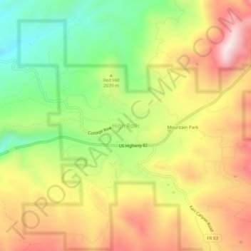
Nombre: Mapa topográfico High Rolls, altitud, relieve.
Lugar: High Rolls, Otero County, New Mexico, 88325, United States (32.93092 -105.85554 32.97092 -105.81554)
Altitud media: 2.036 m
Altitud mínima: 1.756 m
Altitud máxima: 2.322 m
Haz una donación
Equípate para tu próxima aventura:
Como asociado de Amazon, este sitio gana comisiones por las compras que califican, sin ningún costo adicional para usted.
Otros mapas topográficos
Haga clic en un mapa para ver su topografía, su altitud y su relieve.
Cloudcroft
United States > New Mexico > Otero County
Cloudcroft is a village in Otero County, New Mexico, United States, and is located within the Lincoln National Forest. The population was 674 at the 2010 census. Despite being located in an otherwise arid region, its high elevation (8,676 feet (2,644 m); one of the highest in the U.S.) allows for a mild summer…
Altitud media: 2.643 m
La Luz
United States > New Mexico > Otero County
The largest employer in the surrounding area is Holloman Air Force Base. La Luz itself is largely residential and agricultural in land use but a small market is located on the state maintained road that connects the village to Highway 70. La Luz has long been known for the many fruits that are grown in the…
Altitud media: 1.487 m
Alamogordo
United States > New Mexico > Otero County
As of 2010, Alamogordo had a total area of 19.3 square miles (50.0 km2), all of it land. The city is located at an elevation of 4,336 feet (1,322 m) on the western flank of the Sacramento Mountains and on the eastern edge of the Tularosa Basin. It lies within the Rio Grande rift and in the northernmost part of…
Altitud media: 1.515 m
Haz una donación
Equípate para tu próxima aventura:
Como asociado de Amazon, este sitio gana comisiones por las compras que califican, sin ningún costo adicional para usted.
Timberon
United States > New Mexico > Otero County
Timberon is located at 32°37′54″N 105°41′32″W / 32.63167°N 105.69222°W / 32.63167; -105.69222 (32.631675, -105.692254). Timberon is located in a forested valley, known as Sacramento Canyon, on the southern slopes of the Sacramento Mountains. The Sacramento Creek, an intermittent creek,…
Altitud media: 2.181 m
White Sands National Park
United States > New Mexico > Otero County
The first US Army exploration of south-central New Mexico was led by a party of topographical engineering officers in 1849. They passed west of the San Andres Mountains and Organ Mountains. A lieutenant was dispatched east across the basin with a scouting party to map a potential military wagon route to the…
Altitud media: 1.214 m
Alamogordo
United States > New Mexico > Otero County
As of 2010, Alamogordo had a total area of 19.3 square miles (50.0 km2), all of it land. The city is located at an elevation of 4,336 feet (1,322 m) on the western flank of the Sacramento Mountains and on the eastern edge of the Tularosa Basin. It lies within the Rio Grande rift and in the northernmost part of…
Altitud media: 1.427 m
White Sands National Park
United States > New Mexico > Otero County
The first US Army exploration of south-central New Mexico was led by a party of topographical engineering officers in 1849. They passed west of the San Andres Mountains and Organ Mountains. A lieutenant was dispatched east across the basin with a scouting party to map a potential military wagon route to the…
Altitud media: 1.214 m
Haz una donación
Equípate para tu próxima aventura:
Como asociado de Amazon, este sitio gana comisiones por las compras que califican, sin ningún costo adicional para usted.
La Luz
United States > New Mexico > Otero County
The largest employer in the surrounding area is Holloman Air Force Base. La Luz itself is largely residential and agricultural in land use but a small market is located on the state maintained road that connects the village to Highway 70. La Luz has long been known for the many fruits that are grown in the…
Altitud media: 1.487 m
Cloudcroft
United States > New Mexico > Otero County
Its high elevation of 8,676 feet (2,644 m) allows for a mild summer, and the forested mountains make it a tourist attraction for the surrounding deserts. Tourism is the primary economy of the village.
Altitud media: 2.643 m
Cloudcroft
United States > New Mexico > Otero County
Cloudcroft is a village in Otero County, New Mexico, United States, and is located within the Lincoln National Forest. The population was 674 at the 2010 census. Despite being located in an otherwise arid region, its high elevation (8,676 feet (2,644 m) allows for a mild summer and forested surroundings that…
Altitud media: 2.643 m
Haz una donación
Equípate para tu próxima aventura:
Como asociado de Amazon, este sitio gana comisiones por las compras que califican, sin ningún costo adicional para usted.
Alamogordo
United States > New Mexico > Otero County
As of 2010, Alamogordo had a total area of 19.3 square miles (50.0 km2), all land. The city is located at an elevation of 4,330 feet (1,320 m) on the western flank of the Sacramento Mountains and on the eastern edge of the Tularosa Basin. It lies within the Rio Grande rift and in the northernmost part of the…
Altitud media: 1.427 m