
Haz una donación
Equípate para tu próxima aventura:
Como asociado de Amazon, este sitio gana comisiones por las compras que califican, sin ningún costo adicional para usted.
Mapa topográfico Alamogordo
Haga clic en el mapa para ver la altitud.
Haz una donación
Equípate para tu próxima aventura:
Como asociado de Amazon, este sitio gana comisiones por las compras que califican, sin ningún costo adicional para usted.
Alamogordo
As of 2010, Alamogordo had a total area of 19.3 square miles (50.0 km2), all land. The city is located at an elevation of 4,330 feet (1,320 m) on the western flank of the Sacramento Mountains and on the eastern edge of the Tularosa Basin. It lies within the Rio Grande rift and in the northernmost part of the Chihuahuan Desert.:36 Tectonic activity is low in the Tularosa Basin. Plants native to the area are typical of the southern New Mexico foothills and include creosote bush, mesquite, saltbush, cottonwood, desert willow, and many species of cactus and yucca.
Haz una donación
Equípate para tu próxima aventura:
Como asociado de Amazon, este sitio gana comisiones por las compras que califican, sin ningún costo adicional para usted.
Acerca de este mapa
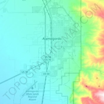
Nombre: Mapa topográfico Alamogordo, altitud, relieve.
Lugar: Alamogordo, Otero County, New Mexico, United States (32.81874 -106.01686 32.94756 -105.91772)
Altitud media: 1.427 m
Altitud mínima: 1.244 m
Altitud máxima: 2.388 m
Haz una donación
Equípate para tu próxima aventura:
Como asociado de Amazon, este sitio gana comisiones por las compras que califican, sin ningún costo adicional para usted.
Otros mapas topográficos
Haga clic en un mapa para ver su topografía, su altitud y su relieve.
Sunspot
United States > New Mexico > Otero County
Sunspot is an unincorporated community in the Sacramento Mountains in the Lincoln National Forest in Otero County, New Mexico, United States, about 18 miles (29 km) south of Cloudcroft. Its elevation is 9,186 feet (2,800 m). The Sunspot Solar Observatory and Apache Point Observatory are located in Sunspot in…
Altitud media: 2.626 m
High Rolls
United States > New Mexico > Otero County
The first official use of the High Rolls name was in 1901, when the post office was moved from Fresnal (Wooten) to High Rolls. The name, which was sometimes spelled as one word, Highrolls, supposedly came from the shape and elevation of the area as compared to the sharper peaks higher up.
Altitud media: 2.036 m
Haz una donación
Equípate para tu próxima aventura:
Como asociado de Amazon, este sitio gana comisiones por las compras que califican, sin ningún costo adicional para usted.
Chihuahuan Desert
United States > New Mexico > Otero County
There are several larger mountain ranges in the Chihuahan Desert, including the Sierra Madre, the Sierra del Carmen, the Organ Mountains, the Franklin Mountains, the Sacramento Mountains, the Chisos Mountains, the Guadalupe Mountains, and the Davis Mountains. These create "sky islands" of cooler, wetter,…
Altitud media: 1.221 m
High Rolls
United States > New Mexico > Otero County
The first official use of the High Rolls name was in 1901, when the post office was moved from Fresnal (Wooten) to High Rolls. The name, which was sometimes spelled as one word, Highrolls, supposedly came from the shape and elevation of the area as compared to the sharper peaks higher up.
Altitud media: 2.036 m
Haz una donación
Equípate para tu próxima aventura:
Como asociado de Amazon, este sitio gana comisiones por las compras que califican, sin ningún costo adicional para usted.
Sunspot
United States > New Mexico > Otero County
The origins of Sunspot as a Solar Observatory date back to the sudden increased interest of solar physics to the US military during the Second World War. In 1940, the High Altitude Observatory (HAO) was established in 1940 in Climax, Colorado, by Walter Orr Roberts and Donald Menzel. It was associated with…
Altitud media: 2.626 m
Cloudcroft
United States > New Mexico > Otero County > Cloudcroft
Cloudcroft is a village in Otero County, New Mexico, United States, and is located within the Lincoln National Forest. The population was 674 at the 2010 census. Despite being located in an otherwise arid region, its high elevation (8,676 feet (2,644 m); one of the highest in the U.S.) allows for a mild summer…
Altitud media: 2.636 m