
Haz una donación
Equípate para tu próxima aventura:
Como asociado de Amazon, este sitio gana comisiones por las compras que califican, sin ningún costo adicional para usted.
Mapa topográfico Tent Lake
Haga clic en el mapa para ver la altitud.
Haz una donación
Equípate para tu próxima aventura:
Como asociado de Amazon, este sitio gana comisiones por las compras que califican, sin ningún costo adicional para usted.
Acerca de este mapa
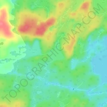
Nombre: Mapa topográfico Tent Lake, altitud, relieve.
Lugar: Tent Lake, Cook County, Minnesota, United States (47.95410 -90.83975 47.95785 -90.83182)
Altitud media: 569 m
Altitud mínima: 543 m
Altitud máxima: 609 m
Haz una donación
Equípate para tu próxima aventura:
Como asociado de Amazon, este sitio gana comisiones por las compras que califican, sin ningún costo adicional para usted.
Otros mapas topográficos
Haga clic en un mapa para ver su topografía, su altitud y su relieve.
Eagle Mountain
United States > Minnesota > Cook County > West Cook
Eagle Mountain is only about 12 miles (19 km) from Minnesota's lowest elevation, Lake Superior, at 600 feet (183 m). It is part of the Canadian Shield. There is also another much shorter peak also named Eagle Mountain in northern Minnesota. The shorter peak is part of the Lutsen Mountains ski resort.
Altitud media: 596 m
Haz una donación
Equípate para tu próxima aventura:
Como asociado de Amazon, este sitio gana comisiones por las compras que califican, sin ningún costo adicional para usted.
Eagle Mountain
United States > Minnesota > Cook County
Eagle Mountain is only about 15 miles (24 km) from Minnesota's lowest elevation, Lake Superior, at 600 feet (183 m). It is part of the Canadian Shield. Confusingly, there is another much shorter peak also named Eagle Mountain in northern Minnesota. The shorter peak is part of the Lutsen Mountains ski resort.
Altitud media: 596 m
Haz una donación
Equípate para tu próxima aventura:
Como asociado de Amazon, este sitio gana comisiones por las compras que califican, sin ningún costo adicional para usted.