
Mapa topográfico Tiberias
Mapa interactivo
Haga clic en el mapa para ver la altitud.
Acerca de este mapa
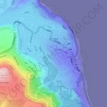
Nombre: Mapa topográfico Tiberias, altitud, relieve.
Lugar: Tiberias, North District, 1424224, Israel (32.77400 35.50376 32.80449 35.54453)
Altitud media: -80 m
Altitud mínima: -218 m
Altitud máxima: 249 m
Tiberias is located on the shore of the Sea of Galilee and the western slopes of the Jordan Rift Valley overlooking the lake, in the elevation range of −200 to 200 metres (−660–660 feet). Tiberias has a climate that borders a Hot-summer Mediterranean climate (koppen Csa) and a Hot Semi-arid climate (koppen BSh), with an annual precipitation of about 400 mm (15.75 in). Summers in Tiberias average a maximum temperature of 36 °C (97 °F) and a minimum temperature of 21 °C (70 °F) in July and August. The winters are mild, with temperatures ranging from 8 to 18 °C (46–64 °F). Extremes have ranged from 0 °C (32 °F) to 46 °C (115 °F).
Otros mapas topográficos
Haga clic en un mapa para ver su topografía, su altitud y su relieve.
Tiberias
Israel > North District > Tiberias
Tveria, Tiberias, Kinneret Subdistrict, North District, 1424224, Israel
Altitud media: -48 m