
Haz una donación
Equípate para tu próxima aventura:
Como asociado de Amazon, este sitio gana comisiones por las compras que califican, sin ningún costo adicional para usted.
Mapa topográfico Ridge
Haga clic en el mapa para ver la altitud.
Haz una donación
Equípate para tu próxima aventura:
Como asociado de Amazon, este sitio gana comisiones por las compras que califican, sin ningún costo adicional para usted.
Acerca de este mapa
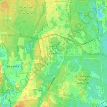
Nombre: Mapa topográfico Ridge, altitud, relieve.
Altitud media: 27 m
Altitud mínima: 10 m
Altitud máxima: 48 m
Haz una donación
Equípate para tu próxima aventura:
Como asociado de Amazon, este sitio gana comisiones por las compras que califican, sin ningún costo adicional para usted.
Otros mapas topográficos
Haga clic en un mapa para ver su topografía, su altitud y su relieve.
Haz una donación
Equípate para tu próxima aventura:
Como asociado de Amazon, este sitio gana comisiones por las compras que califican, sin ningún costo adicional para usted.
Haz una donación
Equípate para tu próxima aventura:
Como asociado de Amazon, este sitio gana comisiones por las compras que califican, sin ningún costo adicional para usted.
Cold Spring Harbor
United States > New York > Suffolk County > Town of Huntington > Cold Spring Harbor
Altitud media: 46 m
Haz una donación
Equípate para tu próxima aventura:
Como asociado de Amazon, este sitio gana comisiones por las compras que califican, sin ningún costo adicional para usted.
Halesite
United States > New York > Suffolk County > Town of Huntington > Halesite > Fort Hill
Altitud media: 31 m
Haz una donación
Equípate para tu próxima aventura:
Como asociado de Amazon, este sitio gana comisiones por las compras que califican, sin ningún costo adicional para usted.
Melville
United States > New York > Suffolk County > Town of Huntington
Long Island's highest point is Jayne's Hill in the neighboring hamlet of West Hills, with an elevation of 387 feet (118 m) to 400.9 feet (122.2 m) above sea level.
Altitud media: 53 m
Haz una donación
Equípate para tu próxima aventura:
Como asociado de Amazon, este sitio gana comisiones por las compras que califican, sin ningún costo adicional para usted.
Manorville
United States > New York > Suffolk County > Town of Brookhaven
Manorville is in the center of Long Island with no access to the water. It lies partially on the Ronkonkoma terminal moraine, which creates some slightly rolling topography, especially in the central portion of the hamlet. The glacial topography of the area features several kettle hole ponds, the most…
Altitud media: 22 m
Haz una donación
Equípate para tu próxima aventura:
Como asociado de Amazon, este sitio gana comisiones por las compras que califican, sin ningún costo adicional para usted.
Haz una donación
Equípate para tu próxima aventura:
Como asociado de Amazon, este sitio gana comisiones por las compras que califican, sin ningún costo adicional para usted.
Village of Port Jefferson
United States > New York > Suffolk County
In 1836 the local leadership initiated the community's transition from a "swampish hamlet" to a busy port town. The 22 acres of the harborfront, which flooded at high tide, were brought to a stable elevation with the construction of a causeway. The village changed its name from "Drowned Meadow" to "Port…
Altitud media: 33 m
Town of East Hampton
United States > New York > Suffolk County
East Hampton is regularly hit by hurricanes and Nor'easters. Given the town's generally flat topography, water often accumulates on town roads stranding motorists in heavy rains.
Altitud media: 3 m
Haz una donación
Equípate para tu próxima aventura:
Como asociado de Amazon, este sitio gana comisiones por las compras que califican, sin ningún costo adicional para usted.
Central Islip
United States > New York > Suffolk County > Town of Islip > North Great River
Altitud media: 20 m
Haz una donación
Equípate para tu próxima aventura:
Como asociado de Amazon, este sitio gana comisiones por las compras que califican, sin ningún costo adicional para usted.
Haz una donación
Equípate para tu próxima aventura:
Como asociado de Amazon, este sitio gana comisiones por las compras que califican, sin ningún costo adicional para usted.
East Setauket
United States > New York > Suffolk County > Town of Brookhaven > Setauket
Altitud media: 40 m
Haz una donación
Equípate para tu próxima aventura:
Como asociado de Amazon, este sitio gana comisiones por las compras que califican, sin ningún costo adicional para usted.
Haz una donación
Equípate para tu próxima aventura:
Como asociado de Amazon, este sitio gana comisiones por las compras que califican, sin ningún costo adicional para usted.
Islip Terrace
United States > New York > Suffolk County > Town of Islip > North Great River
Altitud media: 11 m
Haz una donación
Equípate para tu próxima aventura:
Como asociado de Amazon, este sitio gana comisiones por las compras que califican, sin ningún costo adicional para usted.
Village of Old Field
United States > New York > Suffolk County > Town of Brookhaven
Altitud media: 5 m
Wyandanch
United States > New York > Suffolk County > Wyandanch
The community was formerly known as Half Way Hollow Hills, West Deer Park (beginning in 1875), and Wyandance (in 1888). Topographically, Wyandanch's nutrient-poor loam and sandy soils are part of the outwash plain which was formed as the last glacier melted about 10,000 BCE. The outwash plain slopes gently…
Altitud media: 21 m
Village of Lake Grove
United States > New York > Suffolk County > Town of Brookhaven
Altitud media: 35 m
Haz una donación
Equípate para tu próxima aventura:
Como asociado de Amazon, este sitio gana comisiones por las compras que califican, sin ningún costo adicional para usted.
Setauket
United States > New York > Suffolk County > Town of Brookhaven > Setauket
Altitud media: 14 m
Village of Nissequogue
United States > New York > Suffolk County > Town of Smithtown
Altitud media: 19 m
Amagansett
United States > New York > Suffolk County > Town of East Hampton > Amagansett
Altitud media: 10 m
Haz una donación
Equípate para tu próxima aventura:
Como asociado de Amazon, este sitio gana comisiones por las compras que califican, sin ningún costo adicional para usted.
Village of Shoreham
United States > New York > Suffolk County > Town of Brookhaven
Altitud media: 33 m
Wading River
United States > New York > Suffolk County > Town of Riverhead
The earliest English records show a settlement known as Wading River was founded by eight colonial families. "The spot for the village was chosen with care. There was a stream adequate for water power and abounding in seafood...good water for drinking...soil rich enough to grow essential crops, woodland for…
Altitud media: 23 m
Bohemia
United States > New York > Suffolk County > Town of Islip > North Great River
Altitud media: 17 m
Haz una donación
Equípate para tu próxima aventura:
Como asociado de Amazon, este sitio gana comisiones por las compras que califican, sin ningún costo adicional para usted.
Haz una donación
Equípate para tu próxima aventura:
Como asociado de Amazon, este sitio gana comisiones por las compras que califican, sin ningún costo adicional para usted.
Haz una donación
Equípate para tu próxima aventura:
Como asociado de Amazon, este sitio gana comisiones por las compras que califican, sin ningún costo adicional para usted.
Aquebogue
United States > New York > Suffolk County > Town of Riverhead > Aquebogue
Altitud media: 8 m
Haz una donación
Equípate para tu próxima aventura:
Como asociado de Amazon, este sitio gana comisiones por las compras que califican, sin ningún costo adicional para usted.
Nesconset
United States > New York > Suffolk County > Town of Smithtown > Nesconset
Altitud media: 31 m
Haz una donación
Equípate para tu próxima aventura:
Como asociado de Amazon, este sitio gana comisiones por las compras que califican, sin ningún costo adicional para usted.
Northville
United States > New York > Suffolk County > Town of Riverhead > Northville
Altitud media: 11 m
Haz una donación
Equípate para tu próxima aventura:
Como asociado de Amazon, este sitio gana comisiones por las compras que califican, sin ningún costo adicional para usted.
Haz una donación
Equípate para tu próxima aventura:
Como asociado de Amazon, este sitio gana comisiones por las compras que califican, sin ningún costo adicional para usted.
Village of Lloyd Harbor
United States > New York > Suffolk County > Town of Huntington
Altitud media: 14 m
West Bay Shore
United States > New York > Suffolk County > Town of Islip > West Bay Shore
Altitud media: 3 m
Haz una donación
Equípate para tu próxima aventura:
Como asociado de Amazon, este sitio gana comisiones por las compras que califican, sin ningún costo adicional para usted.
Village of Shoreham
United States > New York > Suffolk County > Town of Brookhaven
Altitud media: 33 m
Haz una donación
Equípate para tu próxima aventura:
Como asociado de Amazon, este sitio gana comisiones por las compras que califican, sin ningún costo adicional para usted.
Kings Park
United States > New York > Suffolk County > Town of Smithtown > Kings Park
Altitud media: 32 m
Haz una donación
Equípate para tu próxima aventura:
Como asociado de Amazon, este sitio gana comisiones por las compras que califican, sin ningún costo adicional para usted.