
Mapa topográfico Πηνειός
Mapa interactivo
Haga clic en el mapa para ver la altitud.
Acerca de este mapa
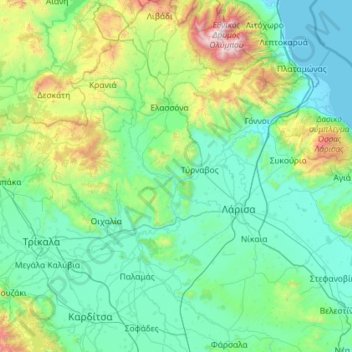
Nombre: Mapa topográfico Πηνειός, altitud, relieve.
Altitud media: 409 m
Altitud mínima: -2 m
Altitud máxima: 2.852 m
Otros mapas topográficos
Haga clic en un mapa para ver su topografía, su altitud y su relieve.
Thessalien - Mittelgriechenland
Griechenland > Thessalien - Mittelgriechenland
Thessalien - Mittelgriechenland, Griechenland
Altitud media: 367 m