
Mapa topográfico Thessalien - Mittelgriechenland
Mapa interactivo
Haga clic en el mapa para ver la altitud.
Acerca de este mapa
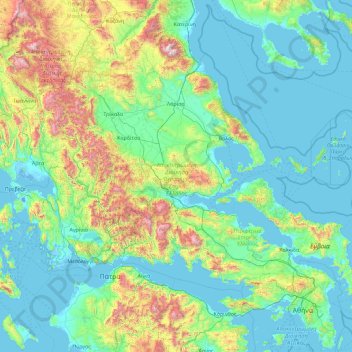
Nombre: Mapa topográfico Thessalien - Mittelgriechenland, altitud, relieve.
Lugar: Thessalien - Mittelgriechenland, Griechenland (37.89138 21.12042 40.19666 24.76990)
Altitud media: 367 m
Altitud mínima: -7 m
Altitud máxima: 2.747 m
Otros mapas topográficos
Haga clic en un mapa para ver su topografía, su altitud y su relieve.
Πηνειός
Griechenland > Thessalien - Mittelgriechenland
Πηνειός, Δήμος Τυρνάβου, Regionalbezirk Larisa, Region Thessalien, Thessalien - Mittelgriechenland, 40007, Griechenland
Altitud media: 409 m