
Haz una donación
Equípate para tu próxima aventura:
Como asociado de Amazon, este sitio gana comisiones por las compras que califican, sin ningún costo adicional para usted.
Mapa topográfico Saldanha Bay Local Municipality
Haga clic en el mapa para ver la altitud.
Haz una donación
Equípate para tu próxima aventura:
Como asociado de Amazon, este sitio gana comisiones por las compras que califican, sin ningún costo adicional para usted.
Acerca de este mapa
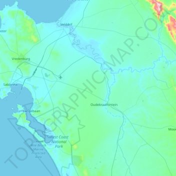
Nombre: Mapa topográfico Saldanha Bay Local Municipality, altitud, relieve.
Altitud media: 60 m
Altitud mínima: -1 m
Altitud máxima: 1.022 m
Haz una donación
Equípate para tu próxima aventura:
Como asociado de Amazon, este sitio gana comisiones por las compras que califican, sin ningún costo adicional para usted.
Otros mapas topográficos
Haga clic en un mapa para ver su topografía, su altitud y su relieve.
Strandfontein
South Africa > Western Cape > West Coast District Municipality > Matzikama Local Municipality
Altitud media: 36 m
Saldanha
South Africa > Western Cape > West Coast District Municipality > Saldanha Bay Local Municipality
Altitud media: 27 m
Clanwilliam
South Africa > Western Cape > West Coast District Municipality > Cederberg Local Municipality
Clanwilliam is situated at an elevation of 100 metres (330 ft), between the western slopes of the Cederberg mountains and the east bank of the Olifants River, which is impounded there by the Clanwilliam Dam. It is located just off the N7 national road, which runs from Cape Town to the Namibian border, and on…
Altitud media: 162 m
Vredendal
South Africa > Western Cape > West Coast District Municipality > Matzikama Local Municipality
Altitud media: 51 m
Haz una donación
Equípate para tu próxima aventura:
Como asociado de Amazon, este sitio gana comisiones por las compras que califican, sin ningún costo adicional para usted.
Vredenburg
South Africa > Western Cape > West Coast District Municipality > Saldanha Bay Local Municipality
Altitud media: 91 m
Langebaan
South Africa > Western Cape > West Coast District Municipality > Saldanha Bay Local Municipality
Altitud media: 34 m
Yzerfontein
South Africa > Western Cape > West Coast District Municipality > Swartland Local Municipality
Altitud media: 8 m
Citrusdal
South Africa > Western Cape > West Coast District Municipality > Cederberg Local Municipality
Altitud media: 256 m
Haz una donación
Equípate para tu próxima aventura:
Como asociado de Amazon, este sitio gana comisiones por las compras que califican, sin ningún costo adicional para usted.
Piketberg
South Africa > Western Cape > West Coast District Municipality > Bergrivier Local Municipality
Altitud media: 265 m
Vanrhynsdorp
South Africa > Western Cape > West Coast District Municipality > Matzikama Local Municipality
Altitud media: 139 m
Wolfberg Arch
South Africa > Western Cape > West Coast District Municipality > Cederberg Local Municipality > Cederberg
Altitud media: 1.413 m
Klawer
South Africa > Western Cape > West Coast District Municipality > Matzikama Local Municipality
Altitud media: 142 m
Haz una donación
Equípate para tu próxima aventura:
Como asociado de Amazon, este sitio gana comisiones por las compras que califican, sin ningún costo adicional para usted.
Saint Helena Bay
South Africa > Western Cape > West Coast District Municipality > Saldanha Bay Local Municipality
Altitud media: 45 m
Bulshoek Dam
South Africa > Western Cape > West Coast District Municipality > Cederberg Local Municipality
Altitud media: 184 m
Riebeek-Kasteel
South Africa > Western Cape > West Coast District Municipality > Swartland Local Municipality
Altitud media: 186 m
Haz una donación
Equípate para tu próxima aventura:
Como asociado de Amazon, este sitio gana comisiones por las compras que califican, sin ningún costo adicional para usted.
Koekenaap
South Africa > Western Cape > West Coast District Municipality > Matzikama Local Municipality
Altitud media: 46 m
Elandsbaai
South Africa > Western Cape > West Coast District Municipality > Cederberg Local Municipality
Altitud media: 43 m
Darling
South Africa > Western Cape > West Coast District Municipality > Swartland Local Municipality
Altitud media: 156 m
Redelinghuys
South Africa > Western Cape > West Coast District Municipality > Bergrivier Local Municipality
Altitud media: 106 m
Haz una donación
Equípate para tu próxima aventura:
Como asociado de Amazon, este sitio gana comisiones por las compras que califican, sin ningún costo adicional para usted.
Darling Wildflower Nature Reserve
South Africa > Western Cape > West Coast District Municipality > Swartland Local Municipality > Darling
Altitud media: 148 m
Hopefield
South Africa > Western Cape > West Coast District Municipality > Saldanha Bay Local Municipality
Altitud media: 58 m
Lambert's Bay
South Africa > Western Cape > West Coast District Municipality > Cederberg Local Municipality
Altitud media: 19 m
Kalbaskraal
South Africa > Western Cape > West Coast District Municipality > Swartland Local Municipality
Altitud media: 75 m
Haz una donación
Equípate para tu próxima aventura:
Como asociado de Amazon, este sitio gana comisiones por las compras que califican, sin ningún costo adicional para usted.
Moorreesburg
South Africa > Western Cape > West Coast District Municipality > Swartland Local Municipality
Altitud media: 172 m
Tafelberg
South Africa > Western Cape > West Coast District Municipality > Cederberg Local Municipality
Altitud media: 1.526 m
Sneeuberg
South Africa > Western Cape > West Coast District Municipality > Cederberg Local Municipality
Altitud media: 1.542 m
Dassen Island
South Africa > Western Cape > West Coast District Municipality > Swartland Local Municipality
Altitud media: 2 m
Haz una donación
Equípate para tu próxima aventura:
Como asociado de Amazon, este sitio gana comisiones por las compras que califican, sin ningún costo adicional para usted.
Porterville
South Africa > Western Cape > West Coast District Municipality > Bergrivier Local Municipality
Altitud media: 207 m
Saldanha
South Africa > Western Cape > West Coast District Municipality > Saldanha Bay Local Municipality
Altitud media: 27 m
Aurora
South Africa > Western Cape > West Coast District Municipality > Bergrivier Local Municipality
Altitud media: 136 m
Velddrif
South Africa > Western Cape > West Coast District Municipality > Bergrivier Local Municipality > Velddrif
Altitud media: 8 m
Haz una donación
Equípate para tu próxima aventura:
Como asociado de Amazon, este sitio gana comisiones por las compras que califican, sin ningún costo adicional para usted.
Hopefield
South Africa > Western Cape > West Coast District Municipality > Saldanha Bay Local Municipality
Altitud media: 58 m
Velddrif
South Africa > Western Cape > West Coast District Municipality > Bergrivier Local Municipality
Altitud media: 8 m
Redelinghuys
South Africa > Western Cape > West Coast District Municipality > Bergrivier Local Municipality
Altitud media: 106 m
Uitkyk
South Africa > Western Cape > West Coast District Municipality > Matzikama Local Municipality
Altitud media: 54 m
Haz una donación
Equípate para tu próxima aventura:
Como asociado de Amazon, este sitio gana comisiones por las compras que califican, sin ningún costo adicional para usted.
Vredendal
South Africa > Western Cape > West Coast District Municipality > Matzikama Local Municipality
Altitud media: 51 m
Krom
South Africa > Western Cape > West Coast District Municipality > Cederberg Local Municipality
Altitud media: 870 m
Clanwilliam
South Africa > Western Cape > West Coast District Municipality > Cederberg Local Municipality
Clanwilliam is situated at an elevation of 100 metres (330 ft), between the western slopes of the Cederberg mountains and the east bank of the Olifants River, which is impounded there by the Clanwilliam Dam. It lies just off the N7 national road, which runs from Cape Town to the Namibian border, and on the…
Altitud media: 162 m
Piketberg
South Africa > Western Cape > West Coast District Municipality > Bergrivier Local Municipality
Altitud media: 265 m
Haz una donación
Equípate para tu próxima aventura:
Como asociado de Amazon, este sitio gana comisiones por las compras que califican, sin ningún costo adicional para usted.
Koekenaap
South Africa > Western Cape > West Coast District Municipality > Matzikama Local Municipality
Altitud media: 46 m
Darling Wildflower Nature Reserve
South Africa > Western Cape > West Coast District Municipality > Swartland Local Municipality > Darling
Altitud media: 148 m
Dassen Island
South Africa > Western Cape > West Coast District Municipality > Swartland Local Municipality
Altitud media: 2 m
Vredenburg
South Africa > Western Cape > West Coast District Municipality > Saldanha Bay Local Municipality
Altitud media: 91 m
Haz una donación
Equípate para tu próxima aventura:
Como asociado de Amazon, este sitio gana comisiones por las compras que califican, sin ningún costo adicional para usted.
Paternoster
South Africa > Western Cape > West Coast District Municipality > Saldanha Bay Local Municipality
Altitud media: 20 m
Langebaan
South Africa > Western Cape > West Coast District Municipality > Saldanha Bay Local Municipality
Altitud media: 34 m
Die Hel
South Africa > Western Cape > West Coast District Municipality > Bergrivier Local Municipality
Altitud media: 621 m
Graafwater
South Africa > Western Cape > West Coast District Municipality > Cederberg Local Municipality
Altitud media: 197 m
Haz una donación
Equípate para tu próxima aventura:
Como asociado de Amazon, este sitio gana comisiones por las compras que califican, sin ningún costo adicional para usted.