
Mapa topográfico Jan Mayen
Mapa interactivo
Haga clic en el mapa para ver la altitud.
Acerca de este mapa
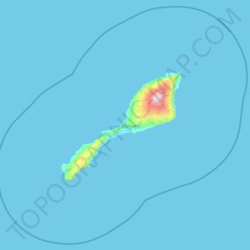
Nombre: Mapa topográfico Jan Mayen, altitud, relieve.
Lugar: Jan Mayen, Norway (70.62614 -9.68463 71.35982 -7.31269)
Altitud media: 23 m
Altitud mínima: -1 m
Altitud máxima: 2.211 m
Jan Mayen consists of two geographically distinct parts. Nord-Jan has a round shape and is dominated by the 2,277 m (7,470 ft) high Beerenberg volcano with its large ice cap (114.2 km2 or 44 sq mi), which can be divided into twenty individual outlet glaciers. The largest of those is Sørbreen, with an area of 15 km2 (5.8 sq mi) and a length of 8.7 km (5.41 mi). South-Jan is narrow, comparatively flat and unglaciated. Its highest elevation is Rudolftoppen at 769 m (2,523 ft). The station and living quarters are located on South-Jan. The island lies at the northern end of the Jan Mayen Microcontinent. The microcontinent was originally part of the Greenland Plate, but now forms part of the Eurasian Plate.
Otros mapas topográficos
Haga clic en un mapa para ver su topografía, su altitud y su relieve.
Li
Norway > Innlandet > Skammestein
Li, Skammestein, Øystre Slidre, Innlandet, 2950, Norway
Altitud media: 774 m
Finnmark
Finnmark, Bamble, Vestfold og Telemark, 3967, Norway
Altitud media: 38 m
Vrådal
Vrådal, Kviteseid, Vestfold og Telemark, 3853, Norway
Altitud media: 433 m
Láhpoluoppal
Láhpoluoppal, Kautokeino, Troms og Finnmark, Norway
Altitud media: 347 m