
Mapa topográfico Hudson
Haga clic en el mapa para ver la altitud.
Hudson
The Assabet River runs prominently through most of Hudson. The river arises from wetlands in Westborough and flows northeast 34 miles (55 km), starting at an elevation of 320 feet (98 m). It descends through the towns of Northborough, Marlborough, Berlin, Hudson, Stow, Maynard, Acton, and finally Concord, where it merges with the Sudbury River to form the Concord River, at an elevation of 100 feet (30 m). The dam in central Hudson is one of nine historic mill or flood control dams on the Assabet River. A portion of the Assabet River National Wildlife Refuge is located in Hudson.
Acerca de este mapa
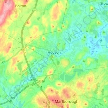
Nombre: Mapa topográfico Hudson, altitud, relieve.
Altitud media: 98 m
Altitud mínima: 51 m
Altitud máxima: 198 m
Otros mapas topográficos
Haga clic en un mapa para ver su topografía, su altitud y su relieve.
Medford Hillside
United States > Massachusetts > Middlesex County > Medford > West Medford
Altitud media: 13 m
Winchester Highlands
United States > Massachusetts > Middlesex County > Winchester
Altitud media: 35 m
Oak Hill
United States > Massachusetts > Middlesex County > Newton
This village is situated on a landform known since the mid-17th century as Oak Hill, and one of the seven principal elevations of Newton (the others being Nonantum Hill, Waban Hill, Chestnut Hill, Bald Pate Hill, Institution Hill, and Mount Ida).
Altitud media: 43 m
Hobbs Road
United States > Massachusetts > Middlesex County > Wayland > Cochituate
Altitud media: 66 m
Cambridge
United States > Massachusetts > Middlesex County > Cambridge
Cambridge obtains water from Hobbs Brook (in Lincoln and Waltham) and Stony Brook (Waltham and Weston), as well as an emergency connection to the Massachusetts Water Resources Authority. The city owns over 1,200 acres (486 ha) of land in other towns that includes these reservoirs and portions of their…
Altitud media: 31 m
Weston Station
United States > Massachusetts > Middlesex County > Weston > Weston Station
Altitud media: 55 m