
Mapa topográfico Lake County
Mapa interactivo
Haga clic en el mapa para ver la altitud.
Acerca de este mapa
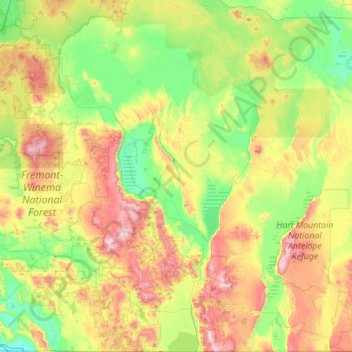
Nombre: Mapa topográfico Lake County, altitud, relieve.
Lugar: Lake County, Oregon, United States of America (41.99301 -121.35122 43.61761 -119.35940)
Altitud media: 1.540 m
Altitud mínima: 1.233 m
Altitud máxima: 2.530 m
Lake County ranges in elevation from 4,130 to 8,446 feet (1,259 to 2,574 m). The highest point in Lake County is Crane Mountain. The mountain is located 6 miles (9.7 km) north of the California border. Lake County has six other peaks with elevations above 8,000 feet (2,400 m), all located in the southern half of the county. Hager Mountain is the highest peak in the northern part of the county.
Otros mapas topográficos
Haga clic en un mapa para ver su topografía, su altitud y su relieve.
Boring
United States of America > Oregon > Boring
Boring, Clackamas County, Oregon, 97009, United States of America
Altitud media: 183 m
Rhododendron
United States of America > Oregon > Rhododendron
Rhododendron, The Villages at Mount Hood, Clackamas County, Oregon, 97049, United States of America
Altitud media: 735 m
Iron Knob
United States of America > Oregon
Iron Knob, Jackson County, Oregon, United States of America
Altitud media: 861 m
Morton Island
United States of America > Oregon
Morton Island, Malheur County, Oregon, United States of America
Altitud media: 661 m
Wemme
United States of America > Oregon > Wemme
Wemme, The Villages at Mount Hood, Clackamas County, Oregon, 97067, United States of America
Altitud media: 494 m
Barlow
United States of America > Oregon > Barlow
Barlow, Clackamas County, Oregon, United States of America
Altitud media: 31 m
McKenzie River
United States of America > Oregon
McKenzie River, Lane County, Oregon, 97413, United States of America
Altitud media: 431 m
Hillsboro
United States of America > Oregon > Hillsboro
Hillsboro, Washington County, Oregon, United States of America
Altitud media: 53 m
Hail Creek
United States of America > Oregon
Hail Creek, Crook County, Oregon, United States of America
Altitud media: 1.412 m