
Mapa topográfico Iron Knob
Mapa interactivo
Haga clic en el mapa para ver la altitud.
Acerca de este mapa
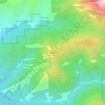
Nombre: Mapa topográfico Iron Knob, altitud, relieve.
Altitud media: 861 m
Altitud mínima: 637 m
Altitud máxima: 1.389 m
Otros mapas topográficos
Haga clic en un mapa para ver su topografía, su altitud y su relieve.
Boring
United States of America > Oregon > Boring
Boring, Clackamas County, Oregon, 97009, United States of America
Altitud media: 183 m
Rhododendron
United States of America > Oregon > Rhododendron
Rhododendron, The Villages at Mount Hood, Clackamas County, Oregon, 97049, United States of America
Altitud media: 735 m
Morton Island
United States of America > Oregon
Morton Island, Malheur County, Oregon, United States of America
Altitud media: 661 m
Wemme
United States of America > Oregon > Wemme
Wemme, The Villages at Mount Hood, Clackamas County, Oregon, 97067, United States of America
Altitud media: 494 m
Barlow
United States of America > Oregon > Barlow
Barlow, Clackamas County, Oregon, United States of America
Altitud media: 31 m
Lake County
United States of America > Oregon
Lake County, Oregon, United States of America
Altitud media: 1.540 m
McKenzie River
United States of America > Oregon
McKenzie River, Lane County, Oregon, 97413, United States of America
Altitud media: 431 m
Hillsboro
United States of America > Oregon > Hillsboro
Hillsboro, Washington County, Oregon, United States of America
Altitud media: 53 m
Hail Creek
United States of America > Oregon
Hail Creek, Crook County, Oregon, United States of America
Altitud media: 1.412 m