
Mapa topográfico Cirencester
Haga clic en el mapa para ver la altitud.
Cirencester
On Cotswold Avenue is the site of a Roman amphitheatre which, while buried, retains its shape in the earthen topography of the small park setting. Cirencester was one of the most substantial cities of Roman-era Britain.
Acerca de este mapa
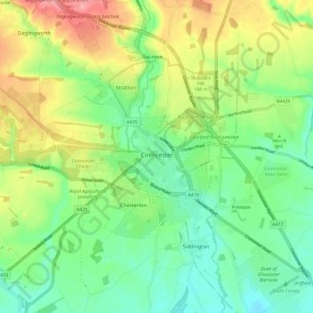
Nombre: Mapa topográfico Cirencester, altitud, relieve.
Altitud media: 128 m
Altitud mínima: 89 m
Altitud máxima: 194 m
Otros mapas topográficos
Haga clic en un mapa para ver su topografía, su altitud y su relieve.
Duntisbourne Abbots
United Kingdom > England > Gloucestershire > Cotswold District
Altitud media: 204 m
Calcot
United Kingdom > England > Gloucestershire > Cotswold District > Coln Rogers
Altitud media: 151 m
Caudle Green
United Kingdom > England > Gloucestershire > Cotswold District > Brimpsfield
Altitud media: 234 m
Bourton-on-the-Hill
United Kingdom > England > Gloucestershire > Cotswold District
Altitud media: 196 m
Hidcote Bartrim
United Kingdom > England > Gloucestershire > Cotswold District > Ebrington
Altitud media: 148 m
Bushley Muzzard, Brimpsfield
United Kingdom > England > Gloucestershire > Cotswold District > Nettleton > Watercombe
Altitud media: 261 m
Knap House Quarry, Birdlip
United Kingdom > England > Gloucestershire > Cotswold District > Birdlip
Altitud media: 222 m
Botany Bay Wood
United Kingdom > England > Gloucestershire > Cotswold District > Stow-on-the-Wold
Altitud media: 171 m
Shipton Oliffe
United Kingdom > England > Gloucestershire > Cotswold District > Shipton
Altitud media: 201 m
Seven Springs
United Kingdom > England > Gloucestershire > Cotswold District > Coberley
Altitud media: 236 m
Nags Head
United Kingdom > England > Gloucestershire > Cotswold District > Avening
Altitud media: 155 m
Winstone
United Kingdom > England > Gloucestershire > Cotswold District > Winstone
Altitud media: 222 m
Eastleach Martin
United Kingdom > England > Gloucestershire > Cotswold District > Eastleach Turville
Altitud media: 111 m
Bledington
United Kingdom > England > Gloucestershire > Cotswold District > Bledington
Altitud media: 118 m
Ablington
United Kingdom > England > Gloucestershire > Cotswold District > Ablington
Altitud media: 136 m