
Mapa topográfico Barnsley
Haga clic en el mapa para ver la altitud.
Acerca de este mapa
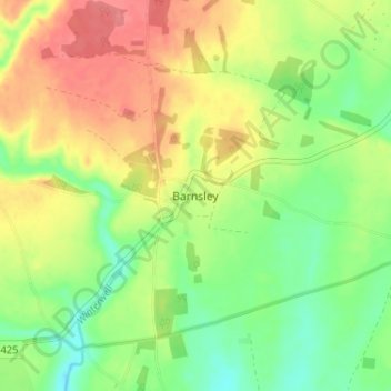
Nombre: Mapa topográfico Barnsley, altitud, relieve.
Altitud media: 135 m
Altitud mínima: 102 m
Altitud máxima: 172 m
Otros mapas topográficos
Haga clic en un mapa para ver su topografía, su altitud y su relieve.
Cirencester
United Kingdom > England > Gloucestershire > Cotswold District
On Cotswold Avenue is the site of a Roman amphitheatre which, while buried, retains its shape in the earthen topography of the small park setting. Cirencester was one of the most substantial cities of Roman-era Britain.
Altitud media: 128 m
Bourton-on-the-Water
United Kingdom > England > Gloucestershire > Cotswold District
Altitud media: 155 m
Worcestershire (detached)
United Kingdom > England > Gloucestershire > Cotswold District
Altitud media: 103 m
Cirencester Park
United Kingdom > England > Gloucestershire > Cotswold District > Sapperton
Altitud media: 162 m
Cold Aston
United Kingdom > England > Gloucestershire > Cotswold District > Cold Aston
Altitud media: 189 m
Bourton-on-the-Hill
United Kingdom > England > Gloucestershire > Cotswold District
Altitud media: 200 m
Coberley
United Kingdom > England > Gloucestershire > Cotswold District > Coberley
Altitud media: 234 m
Bushley Muzzard, Brimpsfield
United Kingdom > England > Gloucestershire > Cotswold District > Nettleton > Watercombe
Altitud media: 261 m
Bibury
United Kingdom > England > Gloucestershire > Cotswold District
The parish is approximately rectangular and stretches far to the rolling, elevated, north. It includes on outlying settlement, Ablington, in the upper valley. Bibury Farm is 300 metres (330 yd) from the village, 151 metres (495 ft) above Ordnance Datum (AOD), which is a similar elevation to much of the north.…
Altitud media: 135 m
Knap House Quarry, Birdlip
United Kingdom > England > Gloucestershire > Cotswold District > Birdlip
Altitud media: 222 m
Botany Bay Wood
United Kingdom > England > Gloucestershire > Cotswold District > Stow-on-the-Wold
Altitud media: 171 m
Evenlode
United Kingdom > England > Gloucestershire > Cotswold District > Evenlode
Altitud media: 134 m
Great Rissington
United Kingdom > England > Gloucestershire > Cotswold District > Great Rissington
Altitud media: 168 m
Bagendon
United Kingdom > England > Gloucestershire > Cotswold District > Bagendon
Altitud media: 171 m
Didmarton
United Kingdom > England > Gloucestershire > Cotswold District > Didmarton
Altitud media: 147 m
Daglingworth
United Kingdom > England > Gloucestershire > Cotswold District > Daglingworth
Altitud media: 169 m
Windrush
United Kingdom > England > Gloucestershire > Cotswold District > Windrush
Altitud media: 155 m
Sherborne
United Kingdom > England > Gloucestershire > Cotswold District > Sherborne
Altitud media: 156 m
Elkstone
United Kingdom > England > Gloucestershire > Cotswold District > Elkstone
Altitud media: 234 m
Down Ampney
United Kingdom > England > Gloucestershire > Cotswold District > Down Ampney
Altitud media: 85 m
Hazleton
United Kingdom > England > Gloucestershire > Cotswold District > Hazleton
Altitud media: 227 m
Chedworth
United Kingdom > England > Gloucestershire > Cotswold District > Chedworth
Altitud media: 187 m
Cirencester
United Kingdom > England > Gloucestershire > Cotswold District
On Cotswold Avenue is the site of a Roman amphitheatre which, while buried, retains its shape in the earthen topography of the small park setting. Cirencester was one of the most substantial cities of Roman-era Britain.
Altitud media: 128 m
Didmarton
United Kingdom > England > Gloucestershire > Cotswold District > Didmarton
Altitud media: 147 m
Cirencester
United Kingdom > England > Gloucestershire > Cotswold District > Chesterton
On Cotswold Avenue is the site of a Roman amphitheatre which, while buried, retains its shape in the earthen topography of the small park setting. Cirencester was one of the most substantial cities of Roman-era Britain.
Altitud media: 128 m