
Mapa topográfico Bibury
Haga clic en el mapa para ver la altitud.
Bibury
The parish is approximately rectangular and stretches far to the rolling, elevated, north. It includes on outlying settlement, Ablington, in the upper valley. Bibury Farm is 300 metres (330 yd) from the village, 151 metres (495 ft) above Ordnance Datum (AOD), which is a similar elevation to much of the north. The south rises to a maximum of 141 metres (463 ft) on its periphery along Akeman Street, a Roman road, before ascending further in other more distant lands. The valley floor within the Bibury boundary, northwest and southeast, ranges from 108 to 98 metres (354 to 322 ft) AOD.
Acerca de este mapa
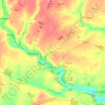
Nombre: Mapa topográfico Bibury, altitud, relieve.
Altitud media: 135 m
Altitud mínima: 94 m
Altitud máxima: 163 m
Otros mapas topográficos
Haga clic en un mapa para ver su topografía, su altitud y su relieve.
Duntisbourne Abbots
United Kingdom > England > Gloucestershire > Cotswold District
Altitud media: 204 m
Calcot
United Kingdom > England > Gloucestershire > Cotswold District > Coln Rogers
Altitud media: 151 m
Caudle Green
United Kingdom > England > Gloucestershire > Cotswold District > Brimpsfield
Altitud media: 234 m
Bourton-on-the-Hill
United Kingdom > England > Gloucestershire > Cotswold District
Altitud media: 196 m
Hidcote Bartrim
United Kingdom > England > Gloucestershire > Cotswold District > Ebrington
Altitud media: 148 m
Bushley Muzzard, Brimpsfield
United Kingdom > England > Gloucestershire > Cotswold District > Nettleton > Watercombe
Altitud media: 261 m
Knap House Quarry, Birdlip
United Kingdom > England > Gloucestershire > Cotswold District > Birdlip
Altitud media: 222 m
Botany Bay Wood
United Kingdom > England > Gloucestershire > Cotswold District > Stow-on-the-Wold
Altitud media: 171 m
Shipton Oliffe
United Kingdom > England > Gloucestershire > Cotswold District > Shipton
Altitud media: 201 m
Seven Springs
United Kingdom > England > Gloucestershire > Cotswold District > Coberley
Altitud media: 236 m
Nags Head
United Kingdom > England > Gloucestershire > Cotswold District > Avening
Altitud media: 155 m
Winstone
United Kingdom > England > Gloucestershire > Cotswold District > Winstone
Altitud media: 222 m
Eastleach Martin
United Kingdom > England > Gloucestershire > Cotswold District > Eastleach Turville
Altitud media: 111 m
Bledington
United Kingdom > England > Gloucestershire > Cotswold District > Bledington
Altitud media: 118 m
Ablington
United Kingdom > England > Gloucestershire > Cotswold District > Ablington
Altitud media: 136 m