
Mapa topográfico Lynn
Mapa interactivo
Haga clic en el mapa para ver la altitud.
Acerca de este mapa
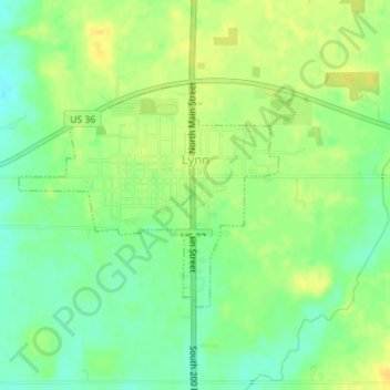
Nombre: Mapa topográfico Lynn, altitud, relieve.
Lugar: Lynn, Randolph County, Indiana, United States (40.03954 -84.95567 40.05503 -84.93216)
Altitud media: 356 m
Altitud mínima: 343 m
Altitud máxima: 367 m
Otros mapas topográficos
Haga clic en un mapa para ver su topografía, su altitud y su relieve.
Union City
United States > Indiana > Randolph County
Union City, Randolph County, Indiana, United States
Altitud media: 333 m
Parker City
United States > Indiana > Randolph County
Parker City, Randolph County, Indiana, 47368, United States
Altitud media: 312 m
Windsor
United States > Indiana > Randolph County
Windsor, Randolph County, Indiana, 47368, United States
Altitud media: 312 m
Farmland
United States > Indiana > Randolph County
Farmland, Randolph County, Indiana, United States
Altitud media: 318 m
Modoc
United States > Indiana > Randolph County
Modoc, Randolph County, Indiana, United States
Altitud media: 355 m
Winchester
United States > Indiana > Randolph County
Winchester, Randolph County, Indiana, 47494, United States
Altitud media: 335 m