
Mapa topográfico Faßberg
Mapa interactivo
Haga clic en el mapa para ver la altitud.
Acerca de este mapa
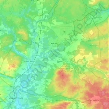
Nombre: Mapa topográfico Faßberg, altitud, relieve.
Lugar: Faßberg, Landkreis Celle, Lower Saxony, 29328, Germany (52.83355 10.05849 52.93660 10.28112)
Altitud media: 77 m
Altitud mínima: 50 m
Altitud máxima: 128 m
Otros mapas topográficos
Haga clic en un mapa para ver su topografía, su altitud y su relieve.
Celle
Germany > Lower Saxony > Landkreis Celle
Celle, Landkreis Celle, Lower Saxony, Germany
Altitud media: 48 m
Wathlingen
Germany > Lower Saxony > Landkreis Celle
Wathlingen, Samtgemeinde Wathlingen, Landkreis Celle, Lower Saxony, 29339, Germany
Altitud media: 44 m
Lohheide
Germany > Lower Saxony > Landkreis Celle > Lohheide
Lohheide, Landkreis Celle, Lower Saxony, Germany
Altitud media: 71 m
Klein Hehlen
Germany > Lower Saxony > Landkreis Celle > Celle
Klein Hehlen, Celle, Landkreis Celle, Lower Saxony, Germany
Altitud media: 42 m