
Mapa topográfico Durisdeer
Mapa interactivo
Haga clic en el mapa para ver la altitud.
Acerca de este mapa
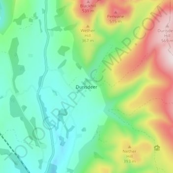
Nombre: Mapa topográfico Durisdeer, altitud, relieve.
Altitud media: 270 m
Altitud mínima: 112 m
Altitud máxima: 589 m
Otros mapas topográficos
Haga clic en un mapa para ver su topografía, su altitud y su relieve.
Fingland
United Kingdom > Scotland > Dumfries and Galloway
Fingland, Dumfries and Galloway, Scotland, DG11 2LD, United Kingdom
Altitud media: 206 m
Eskdalemuir
United Kingdom > Scotland > Dumfries and Galloway
Eskdalemuir, Dumfries and Galloway, Scotland, DG13 0QF, United Kingdom
Altitud media: 246 m
Moniaive
United Kingdom > Scotland > Dumfries and Galloway
Moniaive, Dumfries and Galloway, Scotland, DG3 4HN, United Kingdom
Altitud media: 179 m
Doons
United Kingdom > Scotland > Dumfries and Galloway
Doons, Dumfries and Galloway, Scotland, DG3 4NG, United Kingdom
Altitud media: 202 m