
Mapa topográfico Eastman
Mapa interactivo
Haga clic en el mapa para ver la altitud.
Acerca de este mapa
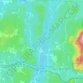
Nombre: Mapa topográfico Eastman, altitud, relieve.
Lugar: Eastman, Memphrémagog, Estrie, Quebec, J0E 1P0, Canada (45.28441 -72.35806 45.37712 -72.24738)
Altitud media: 314 m
Altitud mínima: 241 m
Altitud máxima: 725 m
Otros mapas topográficos
Haga clic en un mapa para ver su topografía, su altitud y su relieve.
Ayers Cliff Exposition Grounds
Canada > Quebec > Memphrémagog > Ayer's Cliff
Ayers Cliff Exposition Grounds, Ayer's Cliff, Memphrémagog, Estrie, Quebec, Canada
Altitud media: 174 m
Mont Éléphant
Canada > Quebec > Memphrémagog > Potton
Mont Éléphant, Potton, Memphrémagog, Estrie, Quebec, Canada
Altitud media: 389 m
Mont Hawk
Canada > Quebec > Memphrémagog > Potton
Mont Hawk, Potton, Memphrémagog, Estrie, Quebec, Canada
Altitud media: 345 m
Mont Singer
Canada > Quebec > Memphrémagog > Potton
Mont Singer, Potton, Memphrémagog, Estrie, Quebec, Canada
Altitud media: 603 m
Lake Memphremagog
Canada > Quebec > Memphrémagog > Stanstead (Canton)
Lake Memphremagog, Stanstead (Canton), Memphrémagog, Estrie, Quebec, Canada
Altitud media: 311 m