
Mapa topográfico Strathpeffer
Mapa interactivo
Haga clic en el mapa para ver la altitud.
Acerca de este mapa
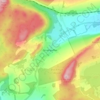
Nombre: Mapa topográfico Strathpeffer, altitud, relieve.
Lugar: Strathpeffer, Highland, Scotland, IV14 9DW, United Kingdom (57.56801 -4.55819 57.60801 -4.51819)
Altitud media: 127 m
Altitud mínima: 18 m
Altitud máxima: 262 m
It lies in a strath 5 miles (8 km) west of Dingwall, with the elevation ranging from 60 to 120 m (200 to 400 ft) above sea level. Sheltered on the west and north, it has a comparatively dry and warm climate.
Otros mapas topográficos
Haga clic en un mapa para ver su topografía, su altitud y su relieve.
Dores
United Kingdom > Scotland > Highland
Dores, Highland, Scotland, IV2 6TT, United Kingdom
Altitud media: 106 m
Drumchork
United Kingdom > Scotland > Highland > Aultbea
Drumchork, Aultbea, Highland, Scotland, IV22 2HU, United Kingdom
Altitud media: 50 m
Kilmore
United Kingdom > Scotland > Highland > Ferindonald
Kilmore, Sleat, Ferindonald, Highland, Scotland, IV44 8RG, United Kingdom
Altitud media: 61 m
Scottish Highlands
United Kingdom > Scotland > Highland
Scottish Highlands, Highland, Scotland, United Kingdom
Altitud media: 907 m
Inverness
United Kingdom > Scotland > Highland
Inverness, Highland, Scotland, IV1 1AN, United Kingdom
Altitud media: 163 m
Ben Nevis
United Kingdom > Scotland > Highland
Ben Nevis, Highland, Scotland, United Kingdom
Altitud media: 912 m
Grampian Mountains
United Kingdom > Scotland > Highland
Grampian Mountains, Highland, Scotland, United Kingdom
Altitud media: 775 m