
Mapa topográfico Grampian Mountains
Mapa interactivo
Haga clic en el mapa para ver la altitud.
Acerca de este mapa
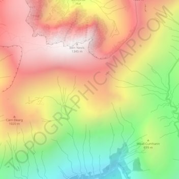
Nombre: Mapa topográfico Grampian Mountains, altitud, relieve.
Lugar: Grampian Mountains, Highland, Scotland, United Kingdom (56.78995 -5.00005 56.79005 -4.99995)
Altitud media: 775 m
Altitud mínima: 119 m
Altitud máxima: 1.338 m
Otros mapas topográficos
Haga clic en un mapa para ver su topografía, su altitud y su relieve.
Rosemarkie
United Kingdom > Scotland > Highland
Rosemarkie, Highland, Scotland, IV10 8UJ, United Kingdom
Altitud media: 44 m
Achintee
United Kingdom > Scotland > Highland > Glen Nevis
Achintee, Glen Nevis, Highland, Scotland, PH33 6TE, United Kingdom
Altitud media: 214 m
Dores
United Kingdom > Scotland > Highland
Dores, Highland, Scotland, IV2 6TT, United Kingdom
Altitud media: 106 m
Drumchork
United Kingdom > Scotland > Highland > Aultbea
Drumchork, Aultbea, Highland, Scotland, IV22 2HU, United Kingdom
Altitud media: 50 m
Strathpeffer
United Kingdom > Scotland > Highland
Strathpeffer, Highland, Scotland, IV14 9DW, United Kingdom
Altitud media: 127 m
Kilmore
United Kingdom > Scotland > Highland > Ferindonald
Kilmore, Sleat, Ferindonald, Highland, Scotland, IV44 8RG, United Kingdom
Altitud media: 61 m
Scottish Highlands
United Kingdom > Scotland > Highland
Scottish Highlands, Highland, Scotland, United Kingdom
Altitud media: 907 m
Inverness
United Kingdom > Scotland > Highland
Inverness, Highland, Scotland, IV1 1AN, United Kingdom
Altitud media: 163 m
Ben Nevis
United Kingdom > Scotland > Highland
Ben Nevis, Highland, Scotland, United Kingdom
Altitud media: 912 m