
Mapa topográfico Scottish Highlands
Mapa interactivo
Haga clic en el mapa para ver la altitud.
Acerca de este mapa
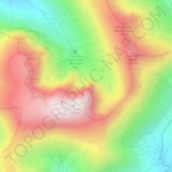
Nombre: Mapa topográfico Scottish Highlands, altitud, relieve.
Lugar: Scottish Highlands, Highland, Scotland, United Kingdom (56.79995 -5.00005 56.80005 -4.99995)
Altitud media: 907 m
Altitud mínima: 470 m
Altitud máxima: 1.338 m
The entire region was covered by ice sheets during the Pleistocene ice ages, save perhaps for a few nunataks. The complex geomorphology includes incised valleys and lochs carved by the action of mountain streams and ice, and a topography of irregularly distributed mountains whose summits have similar heights above sea-level, but whose bases depend upon the amount of denudation to which the plateau has been subjected in various places.
Otros mapas topográficos
Haga clic en un mapa para ver su topografía, su altitud y su relieve.
Dores
United Kingdom > Scotland > Highland
Dores, Highland, Scotland, IV2 6TT, United Kingdom
Altitud media: 106 m
Drumchork
United Kingdom > Scotland > Highland > Aultbea
Drumchork, Aultbea, Highland, Scotland, IV22 2HU, United Kingdom
Altitud media: 50 m
Strathpeffer
United Kingdom > Scotland > Highland
Strathpeffer, Highland, Scotland, IV14 9DW, United Kingdom
Altitud media: 127 m
Kilmore
United Kingdom > Scotland > Highland > Ferindonald
Kilmore, Sleat, Ferindonald, Highland, Scotland, IV44 8RG, United Kingdom
Altitud media: 61 m
Inverness
United Kingdom > Scotland > Highland
Inverness, Highland, Scotland, IV1 1AN, United Kingdom
Altitud media: 163 m
Ben Nevis
United Kingdom > Scotland > Highland
Ben Nevis, Highland, Scotland, United Kingdom
Altitud media: 912 m
Grampian Mountains
United Kingdom > Scotland > Highland
Grampian Mountains, Highland, Scotland, United Kingdom
Altitud media: 775 m