
Mapa topográfico Otaru
Mapa interactivo
Haga clic en el mapa para ver la altitud.
Acerca de este mapa
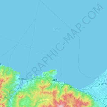
Nombre: Mapa topográfico Otaru, altitud, relieve.
Lugar: Otaru, Shiribeshi Subprefecture, Hokkaido Prefecture, Japan (43.06084 140.81625 43.56736 141.29254)
Altitud media: 79 m
Altitud mínima: -1 m
Altitud máxima: 1.272 m
Otaru is a port town on the coast of the Sea of Japan in northern Shiribeshi Subprefecture. The southern portion of the city is characterized by the steep slopes of various mountains (notably Tenguyama), where the altitude of the land sharply drops from the mountains to the sea. The land available between the coast and mountains has been almost completely developed, and the developed part of the city on the mountain slopes is called Saka-no-machi, or "Hill town", including hills named Funamizaka (Boat-view Hill) and Jigokuzaka (Hell Hill).
Otros mapas topográficos
Haga clic en un mapa para ver su topografía, su altitud y su relieve.
Mt. Fuji
Japan > Sunto County > Oyama
Mt. Fuji, Oyama, Sunto County, Shizuoka Prefecture, Chubu Region, Japan
Altitud media: 3.261 m
Kutchan
Kutchan, Abuta County, Shiribeshi Subprefecture, Hokkaido Prefecture, Japan
Altitud media: 374 m
Yamanouchi
Yamanouchi, Shimotakai County, Nagano Prefecture, Chubu Region, Japan
Altitud media: 942 m
Taku-shima Island
Taku-shima Island, Hirado, Nagasaki Prefecture, Japan
Altitud media: 8 m
Hara
Japan > Suwa County > Hara
Hara, Suwa County, Nagano Prefecture, 391-0104, Japan
Altitud media: 1.235 m
東京湾
Japan > Kanagawa Prefecture > Kawasaki
東京湾, Kawasaki Ward, Kawasaki, Kanagawa Prefecture, Japan
Altitud media: 0 m