
Mapa topográfico Pazardzhik
Mapa interactivo
Haga clic en el mapa para ver la altitud.
Acerca de este mapa
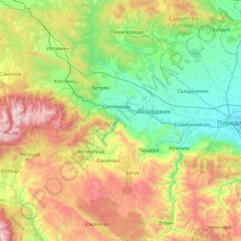
Nombre: Mapa topográfico Pazardzhik, altitud, relieve.
Lugar: Pazardzhik, Bulgaria (41.66851 23.75533 42.62901 24.53780)
Altitud media: 931 m
Altitud mínima: 155 m
Altitud máxima: 2.899 m
The northern parts of the region include the middle ridges of the Sredna Gora mountain, to the south the relief flattens and forms the westernmost parts of the Upper Thracian Plain and to the south are located the Rhodope Mountains where most of the forests are situated. The highest point of the region is Savov Vrah at an altitude of 2,306 m while the lowest altitude is around 200 m in the plains of the central area. The climate is transcontinental with milder winter than northern Bulgaria in the lowlands but with very low temperatures and high snowfall in the mountain areas. The average annual temperature is 11.3 °C.
Otros mapas topográficos
Haga clic en un mapa para ver su topografía, su altitud y su relieve.
River Park
Bulgaria > Sofia-City > Vitosha
River Park, Vitosha, Sofia City, Sofia-City, Bulgaria
Altitud media: 746 m
Graf Ignatievo
Graf Ignatievo, Maritsa, Plovdiv, 4198, Bulgaria
Altitud media: 191 m
Драгойна
Bulgaria > Plovdiv > Dragoynovo
Драгойна, Dragoynovo, Parvomai, Plovdiv, 4293, Bulgaria
Altitud media: 534 m
Panichishte
Panichishte, Sapareva Bania, Kyustendil, 2650, Bulgaria
Altitud media: 1.326 m